Having recently walked the Wonderland Track (which we loved), we decided to come back and see what another walk in Medlow Bath had to offer. Although we didn’t enjoy it as much as the Wonderland Track, it was still a good walk, and it was great to explore a bit more of this lesser visited part of the mountains.
This walk is loosely based on the Glen Rosa Track but has a number of offshoots. It’s all un-signposted and there are quite a few turns to make, so you’ll want a map or copy of these track notes to make sure you don’t miss anything.
Here’s what to expect on the Glen Rosa Track.

The Glen Rosa Track
The stats
Distance: 6.5km
Elevation: 292m
Difficulty: Easy - moderate
Starting the trail to the Three Brothers
The walk begins just off Bellevue Crescent and heads down the fire trail (named Delmonte Avenue on Google Maps), heading slightly left - the path on the right leads to private driveways. The wide track takes you gradually downhill for 950m until you come to a narrow side trail on your left.

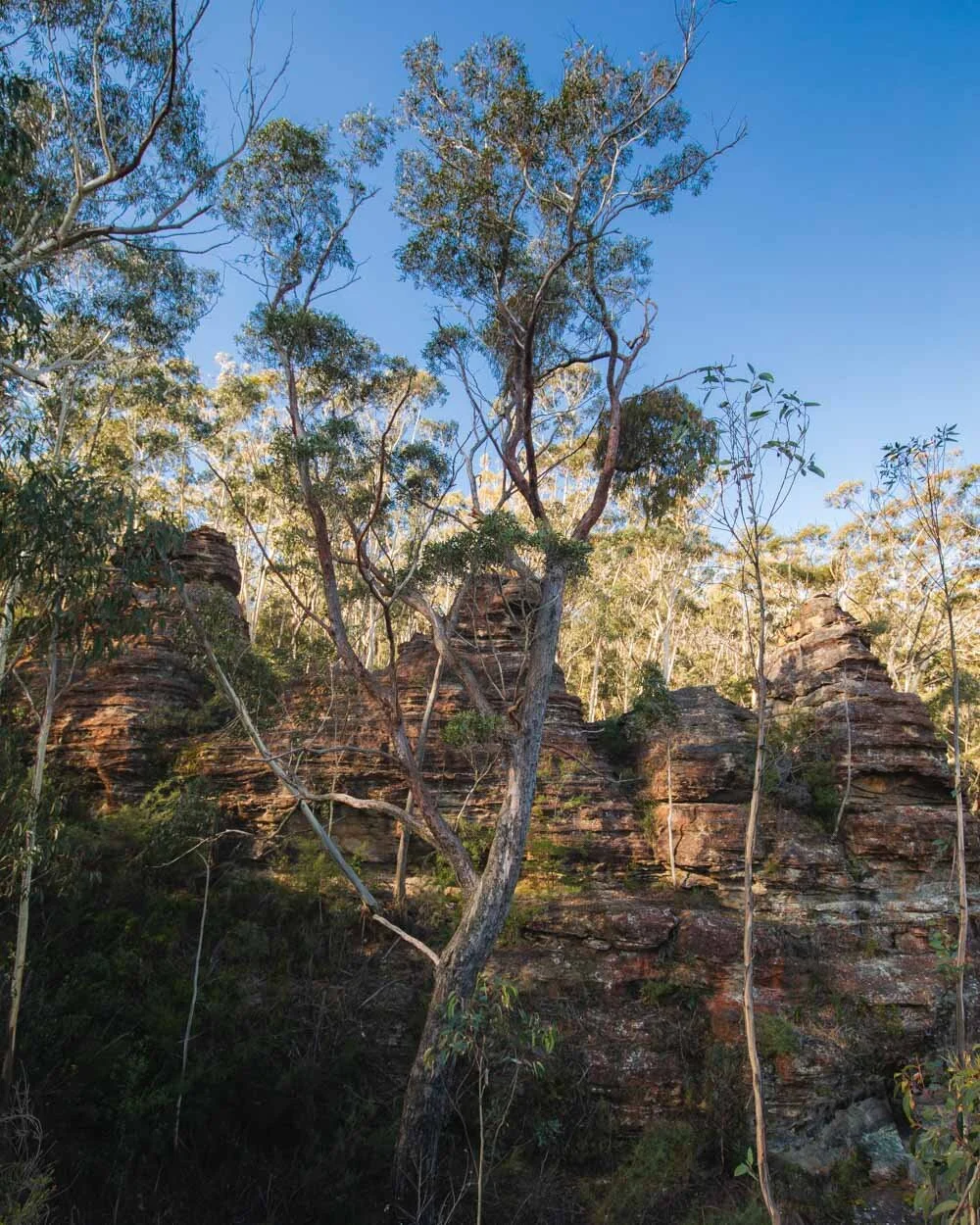
Follow this path for 50m through the bush. You’ll soon come to a junction, continuing on straight for a minute will take you to the Three Brothers rock formations.
You can walk right up to them, but unfortunately we never found an open view where you can actually take them in as one. It’s worth having a look, but just to manage expectations, they are no rival for the Three Sisters!

After visiting the Three Brothers, head one minute back to the junction and follow the other pathway. It only takes a minute to reach a fantastic open view of the Megalong Valley on the right.

Once you leave the viewpoint head back to the narrow pathway that you came in on, but follow it left. After just over 150m you will rejoin the fire trail.
Onto the overhangs
Continue along the fire trail for 90m before taking the path on the left. You’ll see a few remnants of the old flying fox which used to ferry goods up from the Megalong Valley to the Hydro Majestic Hotel!

They are scattered throughout the path and down into the bush, but a very easy access part of the old pulley can be seen 80m down the path by the pylon (on the edge of the cliff).

You can then take the narrow path on the left down the old rickety steps to a series of overhangs (the first overhang is 120m from the old pulley).
You can carefully follow these overhangs, one after the other, for what looked to be quite a while, we turned back after around 150m because it looked like it was possibly a whole other trail, which we might come back to check out one day.

It’s still worth going and taking a look even if you don’t follow it for very far either.
As you walk back towards the steps there are several side trails into the bush, one leads to a nice cliff view and one to another part of the flying fox (the latter ‘path’ is very overgrown and not really worth it).

You then head back onto the main fire trail again.
To the Hydro Majestic via the swamp!
You are back on the main fire trail for roughly 70m before you come to the swamp. Now depending on the water levels this will either be no biggie, or a bit of a squishy affair. For us it was the latter.
There are a number of skinny logs close to the bush to help you cover most of the swamp, but at points you just had to squelch through.

Normally these boggy sections are over really quickly, but this one went on for 170m, which felt far longer than it really is when attempting to avoid the deeper sections of mud and ice cold water!

Once you’re free of the swamp the track heads uphill and you’ll soon get a great view of the Hydro Majestic sitting high on the hill.
Keep following the track uphill for 350m and you’ll pass directly underneath the hotel on a grassy path. At the junction take the left fork, downhill and away from the hotel.

There are some gorgeous tree ferns along this path and you can still see the hotel above you - it was only walking the length of it that I truly realised how massive it is!

Roughly 15m later there is another fork, take the right path up to the ‘Cave house’ which you’ll see 5m later.
Onto the Cave house and some great views
The correct name for the little cave might not be “the Cave House”, but that’s what it looks like. It’s an open overhang where someone has created a window making it look loosely like a house.
It’s a cool little spot although sadly there is a bit of graffiti inside. You’ll then pass another much smaller overhang before walking up onto a wider trail and turning left.


You will then be heading into a section of bushland. Some of the terrain is a little wet at first (but nothing like the swamp) before it dries out completely again.
The next 320m are very straightforward through the forest. There are a number of trees down over the track but none are the big bushy kind, so it’s easy to climb over them.

After 320m take the path on the left which heads downhill. After a few hundred metres you’ll start to get some great views of the Megalong Valley and cliffs of Medlow Bath.


There are numerous side trails leading for a few minutes off to open views. You can check out some of those before heading all the way to the end of the cliff (300m from when you took the left fork).
Onto the tree fern gully
At this point it took us a minute to realise where the path goes because it’s quite old and worn. Just before the rocky outcrop at the end of the cliff look to your left and you will see some faded stone steps carved into the rock.

Head down them and then the path through the bush is very obvious. After just under 200m you will come to a junction and see a rare trail marker on the tree.
One is marked for ‘Sunbath’ and points back the way you came, and one heads right marked as ‘Hotel’.


Your path is un-signposted and continues directly opposite the tree down into the gully. This section of track was a bit wet, muddy, and slippery in places. It reminded me a little of Water Nymphs Dell but not quite as rough.

It’s easy to follow though and after around five minutes you’ll come out at a very pretty area full of huge ferns and giant overhangs. You can explore some of the overhangs before continuing on with the trail.

To the rusty old lookout
From the tree fern path, follow the trail downhill and cross the creek. You’ll pass a narrow part of the walk which is a grassy track with a big sloped drop to the right. It is just a few steps, but it’s exposed and for us it was wet, muddy and a tiny bit slippery.
Just hug the left and tread carefully and you’ll cross it in about four strides (I might not have even noted this bit if it wasn’t muddy, so in very dry conditions you might not think anything of it). Roughly 50m beyond the slippery narrow path you’ll see a track on your right heading slightly downhill.
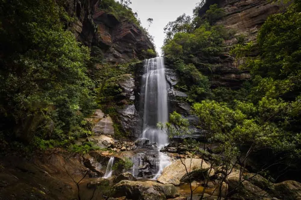
This is a fantastic lookout and clearly used to be maintained as you’ll see the remains of some rusty old railings.


You can see a waterfall (which won’t have much flow unless there’s been very recent heavy rain) and as there was heavy wind it was flowing backwards on our visit. You can also see the landslide that stopped us completing the very end of the Wonderland Track a few weeks ago.
Onto Maxine Bower Cave
The next bit of the walk was a bit tricky to navigate and we went wrong at first, but we’ll do our best to get you there accurately! After leaving the lookout follow the path for approximately 300m before taking a sharp right downhill.
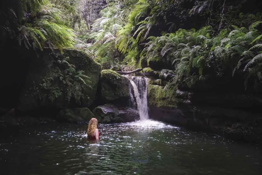
You’ll cross the creek 50m later and then see a small path on your right 20m later. About 30 seconds down this path you’ll see a small waterfall surrounded by ferns. It’s quite sweet although would need a lot of rain to really get going.

Once back on the main trail, follow it uphill. It’s a bit wet and muddy unless you luck out with a long period of dry conditions. After just a few minutes you’ll see a path leading to your left and into Maxine Bower Cave. There are some stone steps leading up into the cave itself.
For us this little side trail was super muddy and slippery. It’s still doable and not too bad getting into the cave, but quite slippery coming back down. Luckily there are trees you can grab if you feel yourself sliding.

It’s well worth making the effort to get into the cave though. It reminded me of Coxs Cave In Mount Victoria and was my favourite spot along the whole track. It’s a big ferny overhang and very atmospheric. You can walk right through the cave on stone steps and along the narrow ledge to get a great view back over the whole cave.


Finishing the track
Once down from the cave and back on the main trail, it’s only 150m until you rejoin the original fire trail. You cross the creek (again it could be wet and slippery but not too bad) and then head uphill to the fire trail.
You then have roughly 1.2km to walk back to where you left your car. It’s flat at first and then has a gradual incline, a nice and gentle hill to finish on.

All in all, it’s a fun little walk and though it won’t be making our list of favourite trails in the Blue Mountains, I am glad to have explored another of the lesser known tracks in the area.
Getting to the Glen Rosa Track
The Glen Rosa Track is located off Bellevue Crescent in Medlow Bath. It’s just 6km and roughly a 10 minute drive beyond Katoomba and 1 hour 40 from Sydney on a good run. Parking is free and unlimited.
If you don’t mind walking a little further you can also take the train to Medlow Bath Station and start from there.
This post may contain affiliate links, meaning at no additional cost to you, that we will earn a small commission if you click through and decide to make a purchase. This helps towards the costs of running our website. Thanks for your support.