Pierces Pass leads down to one of the most spectacular stretches of river we’ve seen anywhere in the Blue Mountains. Taking a dip in the crystal clear water surrounded by huge boulders and towering mountains is nothing short of magical.
Although you could take a dip right off the main track, I swam across a small pool over to a little beach. After crawling under a boulder I emerged to a long stretch of river with deep pools and a wild untouched beauty that makes you forget everything but where you are in that exact moment. It was pure Robinson Crusoe vibes and one of my favourite spots in the Blue Mountains to date.
The downside? It’s quite the hill to climb after your swim. However, even on a 35C day when we were melting on the ascent, I knew every step was worth it.
Here’s everything you need to know about the Pierces Pass walk.

The Pierces Pass Walk
The stats
Distance: 6.2km return, plus around 400m if you want to visit all the swimming spots
Elevation gain: 425m
Difficulty: Moderate, lots of stairs!
Summary: The walk we’re describing in this post only covers one section of the Pierces Pass Track. You can continue all the way to the delightful Blue Gum Forest, which is a much longer endeavour. You can even make it a huge one way track by exiting up Perrys Lookdown or Victoria Falls (but this requires a car shuffle).
We’re covering the section of the track that leads down to the Grose River. There is a well maintained trail the whole way and no tricky terrain. The climb back up is steep in parts, but also has some long flat or gradual sections to break it up - it’s still tiring though!

Starting the trail: to Pierces Creek
From the parking area (details below) the trail heads directly into the bush and is well signposted. You’ll begin descending immediately and the first 250m are relatively steep. The path is excellent however, with well maintained steps or a good dirt track.


The descent then becomes much more gradual as you hike between the shady gum trees. After 600m you’ll get your first glimpse of the mountains to your left, but it’s nothing on what’s to come further along the trail.
After another 100m you’ll enter a gorgeous rainforest gully. There’s a signposted turning for Pierces Creek, which is a brief detour.

This little section of track is less well maintained and is a bit slippery and muddy (after rain). It’s only a 50-100m (depending on how far you go) side trail though and worth doing even the first few steps down to see the pretty cascades.

The temperature noticeably cools and the sound of rushing water makes it incredibly peaceful. Or it would if it weren’t for the ferocious mosquitos.
We were walking after rain on a hot day and they were relentless, however, they thankfully aren’t a problem along the rest of the track.
The descent continues
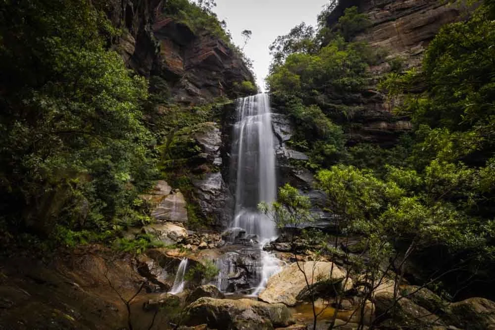
The descent continues through the rainforest and passes a small waterfall after about 950m (slightly less if you didn’t detour to Pierces Creek).
Just 50m past this waterfall is an informal trail leading down to the creek. It’s a bit steep and had a thick covering of leaf litter making it quite slippery, so go carefully.

The cascades are fabulous here, crystal clear and surrounded by mossy boulders creating tiny little pools.
Not big enough for a dip, but big enough to paddle your feet - there may be deeper ones elsewhere, but exploring the creek further is an adventure for another day!


After another 150m on the main track you’ll leave the rainforest behind and enter dry forest once again. But this time there are views, and they are stunning!
Though often partially obscured by trees, the mountains are now surrounding you and it’s incredibly dramatic.

Reaching the river
The gentle descent is still on a great track so you can really take in all the gorgeous scenery as you head towards the river.

Roughly 1km after you start to get those big mountain views you’ll pass an informal campsite on your left. It’s a small clearing but there are some big stones here you can take a break on if required.


From this point the track gets a little steeper, it’s still on a good path for another 400m and then you hit a rocky section.

It’s not difficult terrain and wasn’t slippery, but after quite a long descent already it does feel a bit harder as you have to start watching your footing. However, it’s only a couple of hundred metres before you come to a few stairs and then emerge onto a flat, partially eroded gully.
You’re now just moments from the river, which you’ll arrive at roughly 2.9km after leaving the car park.
Exploring the Grose River
The walking track will bring you to a river crossing and the view from here is simply sensational. There’s a relatively deep pool backed by steep forested slopes and the looming mountain behind.
This is actually a really nice swimming spot in and of itself.

You are right on the walking trail, so it’s not secluded, but we didn’t see another soul here, so it’s not really an issue. However, since you’ve made all the effort to get down here, you’ll definitely want to spend some time exploring more of the river.
You can venture both up and downstream. Upstream is the best for swimming and downstream is the most picturesque area, but isn’t ideal for swimming as it’s shallow.
Heading to the pools upstream
110m from the crossing, co-ordinates: -33.5805174, 150.3352290
Going upstream means you’ll probably get wet feet as you need to cross the creek (or swim across the pool).
The crossing has plenty of rocks to use as stepping stones, but many were submerged on our visit - although it’s possible in drier times you might make it across without wet boots.

The best way to get to the pool upstream is to stick close to the river and use the rocks alongside the water, not the hiking trail that runs parallel to the river.
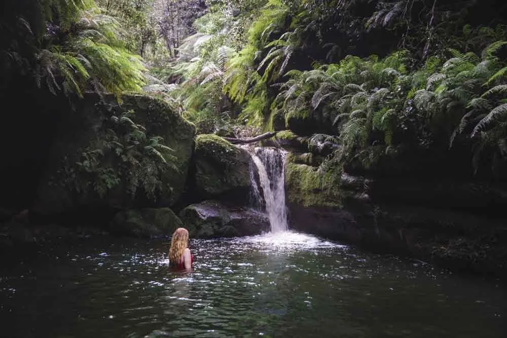
Personally as I was planning to swim anyway, I got straight into the pool and swam across to the small beach on the other side. Joe crossed the river on the rocks and climbed along the boulders to reach the same spot.
From the beach I looked back at the crystal clear water and ahead to the small gap between two giant boulders and I knew instantly that the climb back up, even in 35C heat, would be worth it.

It had such an incredible wild feel to it, and though I generally prefer waterfall pools to river swims, this place is really special.
If you aren’t going to swim across the pool, then you’ll need to clamber around the rocks to get to the beach. This part is a little slippery and narrow, so watch your footing and make sure you have some good handholds as well. You wouldn’t slip far, but you would get wet!

From the beach, head through the gap between the two boulders. You’ll then need to pass under the fallen tree before coming to a rock platform that runs alongside the river.
You can either wade, or walk along the edge here for roughly 100m to two deeper pools.


This section of the river is completely cut off from the main walking track and feels utterly wild. The two sections of river just before the cascades are deep enough for a proper swim.

You don’t get quite such dramatic mountain views at this spot, but it’s still spectacular and this is your best bet for proper swims due to the depth of the water and the fact you have a bit more space.

Exploring the Grose River downstream
70m (ish) from the crossing, co-ordinates: -33.5820888, 150.3354460
From the main river crossing you can also explore downstream. The downstream area had my favourite pool of all, not for swimming as it’s quite shallow and has a current, but for scenery it’s a hard spot to beat.
The pool is enclosed by boulders and two mountain peaks soar majestically behind it making for one of the most magical swimming holes in the Blue Mountains.

The majority of the pool is only waist deep and the current coming from the cascades was surprisingly powerful - especially given there was little to no current in the other pools I swam in - so I mainly just lazed around on the rocks dipping in and out of the water.

If that sounds good to you then there are two ways to reach this spot.
The first is to cross the river at the point where the walking track signpost is (the main creek crossing) and then follow the path left for around 70m.
The dirt path is mainly flat but has a few rocky sections. It’s easy, though I wouldn’t necessarily recommend walking it barefoot like I did!

When you get close to the coordinates, you’ll see a couple of social paths leading down from the main track to the water on your left. Follow the one that looks easiest to you and you’ll see the pool, to help guide you the coordinates are -33.5820888, 150.3354460
The path I took down to the river had a little loose soil and debris, as well as some rocks to climb over, but it’s only a few metres off trail.

Alternatively, you can take the unofficial route from the main creek crossing which will bring you out to the right side of the pool (the opposite side to the official track). For this route you don’t need to cross the creek and can instead head left at the signpost (downstream) following the social trail through the bush. Though there isn’t a proper path the terrain is good and it’s not very overgrown. This route is a little more direct than the creek crossing version so it will be a little shorter in distance.
When you’re ready to leave the beautiful river - which is hard to do, so give yourself plenty of time - you simply retrace your steps back up the main walking trail. The first 1km and last 250m are the steepest. Inbetween you’ll have some flat sections or a much more gentle gradient.

Keep them wild
Please remember to take all rubbish with you and keep these places wild and pristine - as with anywhere in the outdoors. It’s important to leave them exactly as you found them so they will remain beautiful for generations to come.
Litter tends to breed litter, so if you do spot any and are able to pick it up and dispose of it outside the national park, it will go a long way to keeping the area clean.
Where to park and getting to the trailhead
The trail begins from the Pierces Pass Picnic Area where there is a smallish car park, but we’ve never seen it full. There’s a long drop toilet here, but no running water.
It’s around 24km and a 25 minute drive from Bilpin, 37km and a 35 minute drive from Katoomba and 115km and a 1 hour 50 minute drive from Sydney.
This post may contain affiliate links, meaning at no additional cost to you, that we will earn a small commission if you click through and decide to make a purchase. This helps towards the costs of running our website. Thanks for your support.