Despite being touted as the next big walk in 1931, it’s clear by the lack of people that have heard of it, that Bruce’s Walk didn’t stand the test of time. However, for those seeking to go a little off the beaten track, there’s a few treasures along the trail which make it more than worth your while.
The full track extends between Medlow Bath and Lawson, but it can be broken down into a couple of different sections. We opted to walk between Wentworth Falls and Lawson because we were keen to find the ‘lost’ cave waterfall that exists along this stretch of the track.
The waterfall itself has a good story behind it which we’ll share later in the post.

Bruces Walk: Wentworth Falls to Lawson
The stats
Distance: 11.1km including side trails (but less if you do a car shuffle or use a taxi)
Elevation gain: 575m
Difficulty: Moderate, but very slippery and steep trail
Bruces Walk is easy to follow, but unmaintained. Depending on recent weather conditions it can be a moderate or more difficult walk. We visited around a week after very heavy rain and there was plenty of muddy slippery track and lots of fallen trees and other debris. Had we have known what the track would be like, we would definitely have let it dry out for quite a bit longer and would recommend not walking after heavy rain.
There are four ladders along the track, but none are hard or exposed. The ‘trail’ to the waterfall is not marked and unless you know where to look you would never know it was there. After a lot of rain the trail to the waterfall will definitely mean wet boots and also involves traversing unstable eroded dirt track - reason alone to let the trail dry out.

Track logistics
This is a station to station walk, but does involve a fair amount of walking along the road either side of the trail. For this reason if you have two cars you can cut off all the road walking, which knocks about 3.2km off the total distance of the trail. You could also park your car at Lawson and take a taxi or uber to the start of the walk at Wentworth Falls, which would knock 2.4km off the track and avoid the majority of road walking.
Having said that, the roads are very quiet and actually quite pretty, with views for some of the time. It’s not exactly a hardship, but worth noting if you’d rather stick to the bush track only.
Starting the track at Wentworth Falls Station
We’ll write the notes from the station, but if you’re planning to do a car shuffle or catch a lift then skip this section and head to the start of the bush track.
The total walk from the station to the start of the official trail is just under 2.4km.

From Wentworth Falls station (when facing the road) head right (north). You’ll walk over the bridge and then take the right fork along Henderson Road after 450m.


You’ll follow this road (there’s always a pavement) for just over a kilometre before turning right onto Lawson View Parade. The road is quiet, pretty and leafy.
There are some fab houses with incredible views which kept us entertained along the way.

The bush track begins at the end of Lawson View Parade which is 840m from the turn off. You’ll come to a Blue Mountains National Park sign so you know you’re in the right place.


Into the bush
The trail is not signposted, but if you head right as you near the end of the grassy section you’ll see it heading into the bush. There are a couple of side trails in quick succession and you need to head right at both.

The track begins heading downhill and at first it’s quite an easy path - a bit rocky, but it holds up well after rain. This then gives way to fire trail which is relatively flat and then you’ll arrive at a pylon just under 1km after entering the bush.
It’s not actually very obvious where the the path goes, but look to the left of the pylon and you’ll see a few stones steps leading you down.


As you descend further into the bush and begin entering the damp forest, the path gets much muddier (unless you’re walking after a prolonged dry spell).
It gets pretty steep at points despite the switchbacks and there is a fair amount of leaf litter and general debris along the path.

In terms of scenery it’s pretty enough bushland, with some lovely ferns, but this is not your typical jaw-dropping Blue Mountains vistas.
This is why I’d recommend this hike for those that like to do the lesser known tracks as opposed to people that don’t have much time to spend in the area.

Arriving at Shelter Cave
After descending roughly 500m beyond the pylon you’ll almost reach the creek and see an obvious side trail on your left - it’s next to a huge fallen log that you’d need to clamber over to continue the trail.
It takes just a couple of minutes to walk up into Shelter Cave.

It can be muddy but it’s not very slippery and easy enough. I love these old shelter caves which are scattered throughout the mountains, and this one has the remnants of a couple of bench seats which makes it feel quite atmospheric.

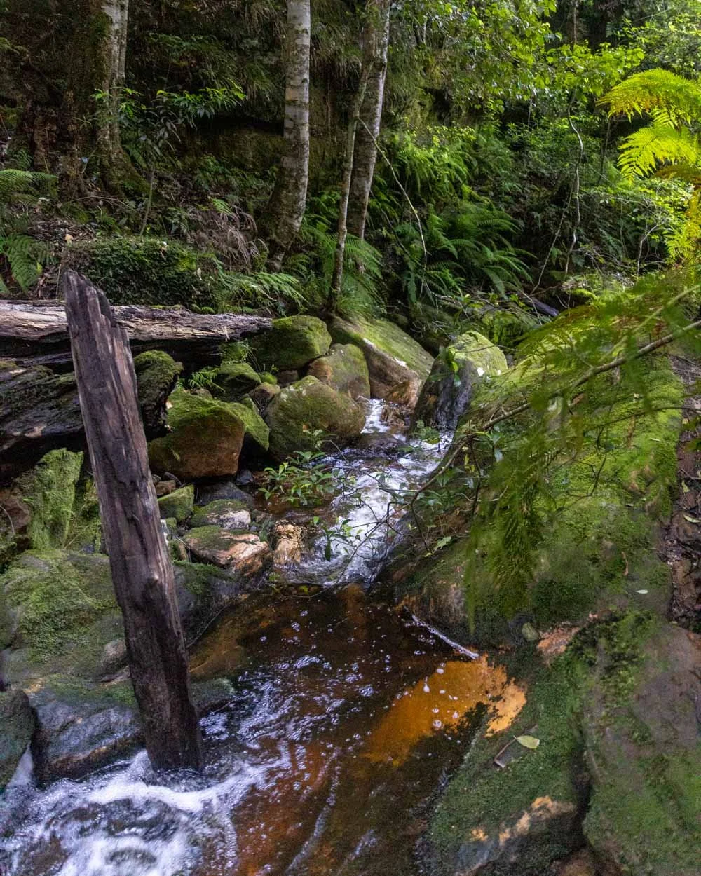
After visiting the cave you walk back to the main trail and head to the creek, which is just 100m away. You can see a small waterfall and canyon here which are very pretty, although we couldn’t easily see a way down.
Next you cross over the creek, which is probably normally very low, but for us involved walking up a short slightly rotten log to avoid wet boots.


From here the track begins ascending.
Climbing to the cliff tops
The narrow path begins ascending and it’s much drier than on the forested side.
There is one short stretch of track which is pretty steep though and I was aware a slip here would not be good, but luckily the path was not slippery.

Apart from that one patch, it’s a narrow track, but doesn’t feel precarious. It also gets a lot less steep and has some flat sections as you head on.


It’s only 600m to the top of the cliffs and the next pylon, but in that short time you climb 140m in elevation, so it’s steeper than your average mountains track.
From here you have a couple of hundred metres along the fire trail before you come to a junction. You need to leave the fire trail and head along the bush track which is marked with white tape (which you’ll see at other points along the trail and reassures you that you’re on the right path).
It’s the path in-between the bush track on the left and continuing along the fire trail.

Descending to Podgers Glen
As quickly as you climbed up, you now have to descend again, but it’s easier and less slippery than the first descent to the Shelter Cave (whilst still being pretty steep at points).
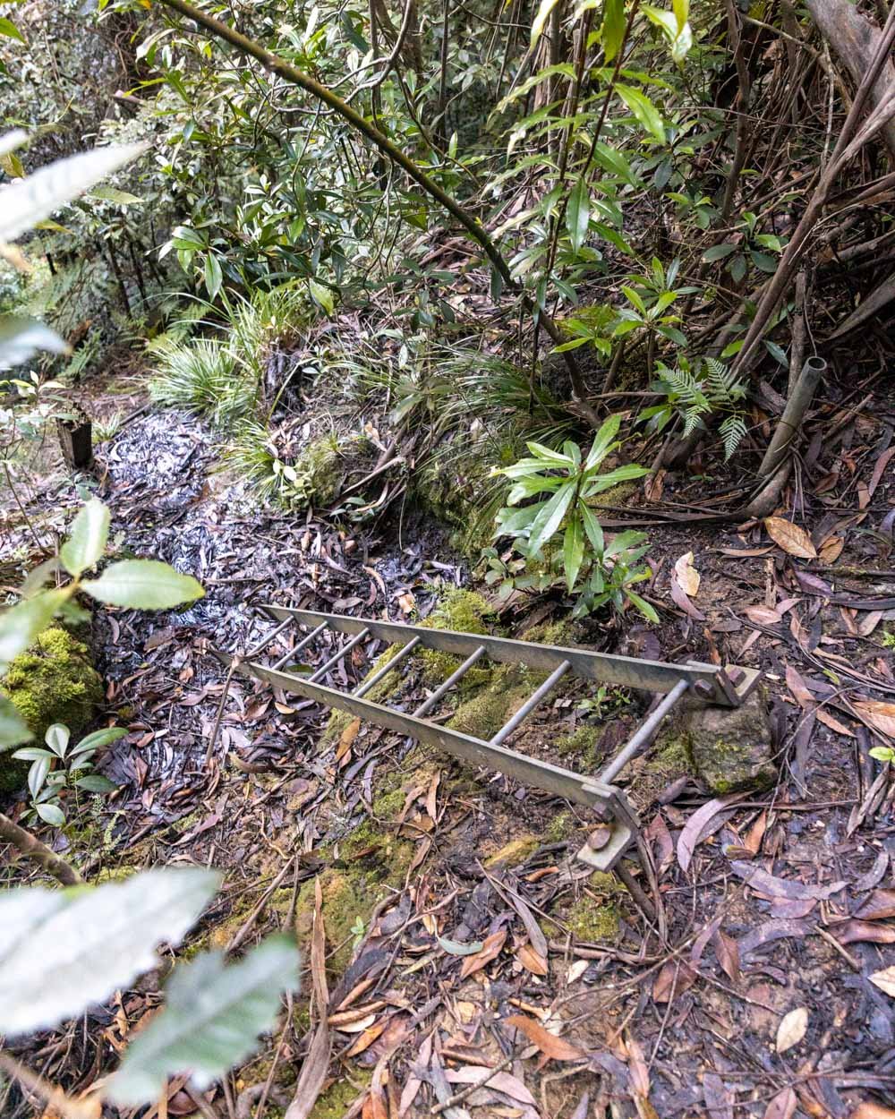
After roughly 700m along a dirt track in the forest, you’ll reach your first and longest ladder. It’s nice and sturdy and doesn’t feel exposed at all. It’s quite narrow, but easy enough to descend.

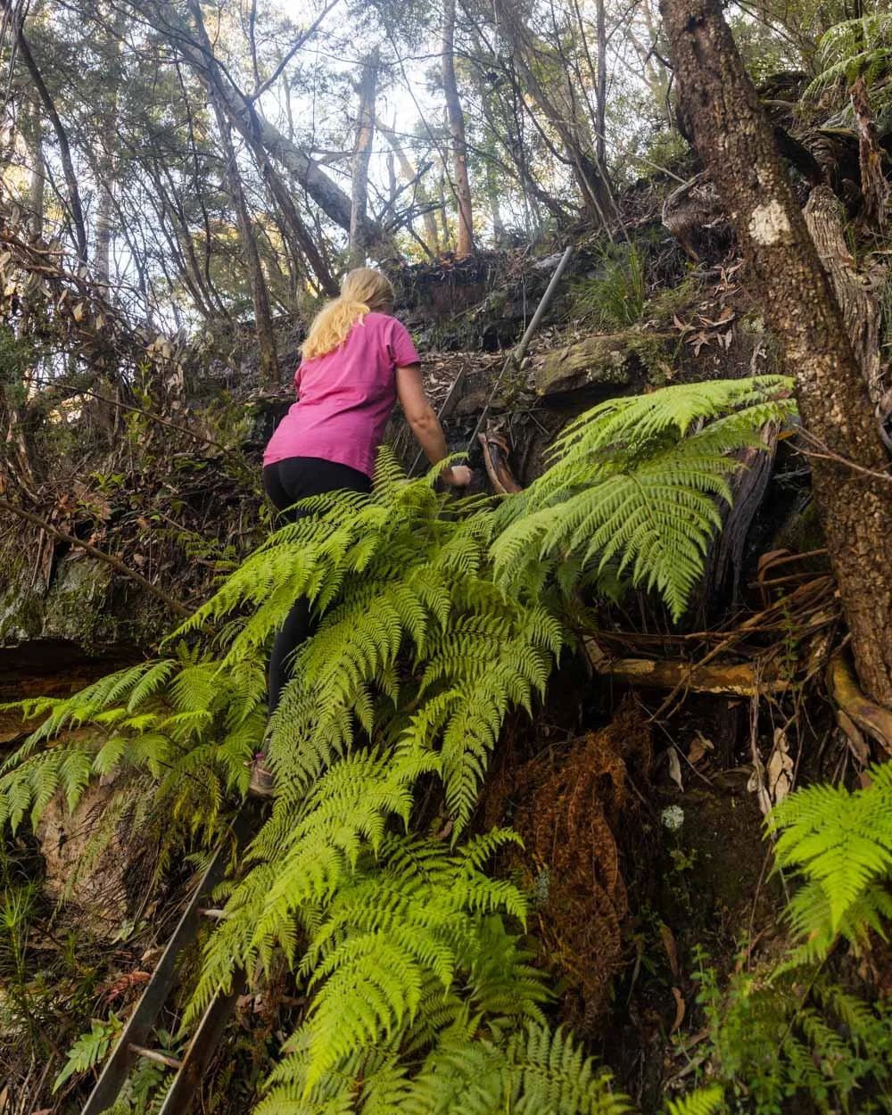
You’ll then continue heading downhill along a dirt track for a couple of hundred metres more before you hit the next two ladders which are almost back to back.
The first is very short and sturdy and the second is wooden rather than metal, and looks a bit worse for wear.

After feeling a bit dubious it actually felt totally fine under my weight, so it wasn’t a problem and the ladders did make the track feel a little more fun and adventurous than the ultra manicured trails which are maintained by the parks service.
From the ladders you head down a little gap in the rocks and have a few hundred metres more quite steep descent on muddy track until you’re standing at the creek in Podgers Glen.


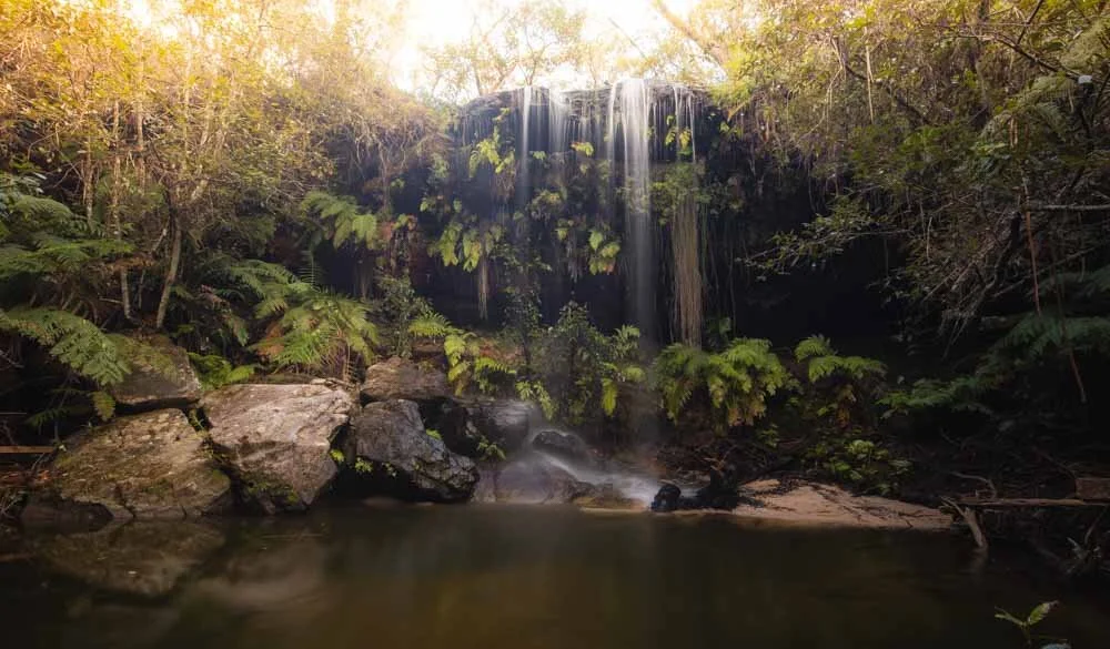
The elusive Lawson Cave Falls
The next bit of this walk will be easier for you than it was for us because we’re going to tell you exactly how to get there!
I am a little embarrassed to admit that what will probably take you less than 10 minutes took us two hours - a delay we definitely did not account for which you’ll is why you won’t see any photos in the last section of this post….

Anyway back to the falls, and the reason they are known as the “lost falls” is because there was no public account of them between 1912 and 2013. You can read the full story here but essentially they were rediscovered after a 9 year search following a sighting of the falls in an old photograph in Lawson Library.
And let me tell you, it was worth searching for! The majestic waterfall flows into a dark cave, the beauty of which is up there with some of the most spectacular falls in the mountains. The tall cave walls give it a mysterious vibe and the fact it’s off the beaten track makes it feel like a real hidden treasure.

Finding Lawson Cave Falls
A word of caution before you head to the falls - this is best not done after heavy rain. What little track there is becomes waterlogged and easily eroded and there is a higher risk of tree fall. You’re also guaranteed to get wet boots if the creek is flowing high.

The heavy rains between 2020 and 2022 have made this trail more difficult, as there are a lot of fallen logs and branches. It’s doable, but don’t expect a straightforward walk up the creek.
The distance between the main creek crossing as you arrive in Podgers Glen and the waterfall is just 600m.
Directions to Lawson Cave Falls
Assuming it all looks good, you need to head upstream aiming for these coordinates: -33.7166490, 150.4027418 (you can find it on Google Maps by clicking here).
Facing upriver, you’ll need to follow the creek that heads in a southwesterly direction.
The easiest way to get there is to cross the creek (there are stepping stones where the main trail will lead you to) and instead of continuing along the main track on the other side of the creek, take the rough path upstream.

At first it’s easy to follow and pretty easy to walk. The path will cross the creek a little further up and there are rocks to use as stepping stones again. It is a bit overgrown at points with huge ferns covering the path, but you will be able to follow it without issues.
You will then come to what feels like a dead end with the creek now on your left. The dirt track abruptly ends and you will be staring at some small cascades with big mossy boulders (and steep walls on either side).

This is what threw us off and had us exploring other avenues before returning and realising this had to be the way.
Depending on how you feel, you can climb up the big boulders and over to the other side of the creek, or go through the water (for me this was chest height) which skips climbing the first two boulders which were quite big and slippery.

The boulder route

The water route
Continuing upstream you’ll have two choices - continue clambering over the boulders and try to head through the water, or hike through the bush to your left.
We opted to walk in the bush as it looked like there used to be a trail here, but when we hiked it had all but vanished. Instead we traversed some really narrow slippery mud tracks holding onto the trees for support when needed - I wouldn’t do this again unless it was very dry because it did feel unstable.
You could walk in the water to skip part of this, but the water had some obstacles too, so we stuck with higher ground.
You will then leave the bushy area and scramble down into the creek, which is not too difficult. From here you make your way up the creek.
This bit is easy apart from having to navigate some significant debris. Be careful when climbing over the final log pile (which is pretty big) as the logs are rotten and give way easily.

If you walk this when really dry you will probably think my description is pretty OTT, but for us this was definitely more dodgy than expected and in hindsight we should have let the whole track dry out for much longer - lesson learnt!
After 600m of hiking you will be at the falls!


Luckily the falls were worth the effort and there are plenty of rocks to sit on and take in the beauty of this mysterious cave waterfall. It was even better than I had imagined, photos definitely don’t do it justice.

As we left the waterfall we saw another big cave at the top of the creek on the right.
Unfortunately the path was steep and very muddy, so we just admired it from below, but in drier times it would only take a couple of minutes to reach.
Onwards to Claire’s Glen
Once you’re back at the main track again you continue following the path which heads up to the cliff tops. It’s a steep but easy ascent (110m elevation over 500m).


There weren’t any bits that felt dodgy and it was a quick 500m stretch of track that was all very stable and dry. Part way up you’ll reach the fourth and final ladder.
This one does move a little bit, but it’s very short and did take our weight without feeling like it might buckle!

Once you arrive at the top you’ll be at yet another pylon, keep left and you’ll reach a second pylon 50m later. From here the trail goes back into the bush on your left.

It’s a much shorter and shallower descent to the next glen, but there is some debris and one small landslide to negotiate.
The total descent is 700m before you reach the creek and it’s pretty gorgeous and ferny along the way. The ferns do cover the odd fallen log though so take care with footing. Claire’s Glen itself is very pretty with mossy trees and huge ferns, but not on the scale of Podgers Glen.

Once you cross the creek - which is easy and involves just one big step across - you will begin the ascent up to the fire trail.
It was at this point that it got dark and we couldn’t take any more photos!
Finishing the trail
The climb out of Claire’s Glen is significantly less steep than the first two climbs. It’s actually the same distance as the climb up out the second valley, but it doesn’t have the same elevation gain.
It was already getting dark for us at this point so I can’t tell you much, except that it’s a good path with one additional tiny creek crossing. It’s nicely forested and gets rockier and drier as you reach the next pylon.
From here you have around 1.3km walking on wide fire trail. It’s mainly flat and very easy. You need to turn left at Kent Street Fire Trail and then follow all the signs for Kent Street for the next 900m.
After 1km on the fire trail the path curves right and you need to take a sharp right 200m later. From here you have 50m before you turn left and head downhill into the bush again.
This is quite a steep and rocky descent on an eroded track. It’s not too difficult, but after the fire trail it suddenly feels like you have to concentrate again. After a 150m descent you will cross the creek (plenty of rocks) and then ascend on a similar track until you reach a fire trail again 200m later. At the top, turn left following the sign for Dantes Glen. You’re now just 400m away from North Lawson car park.
If you still have time and energy you could detour to see some of the waterfalls along the North Lawson Waterfall Circuit. It would add on a few kilometres but it’s a gorgeous walk and all on a well maintained track.
Heading back to Lawson Station
Assuming you haven’t got a car waiting for you at North Lawson Park, you’ll need to walk 800m back to the station. It’s on fairly quiet roads (not all with pavements but they’re wide).
Unfortunately the start of the walk back is all uphill and relatively steep. After that it flattens and it’s more leisurely.
This post may contain affiliate links, meaning at no additional cost to you, that we will earn a small commission if you click through and decide to make a purchase. This helps towards the costs of running our website. Thanks for your support!