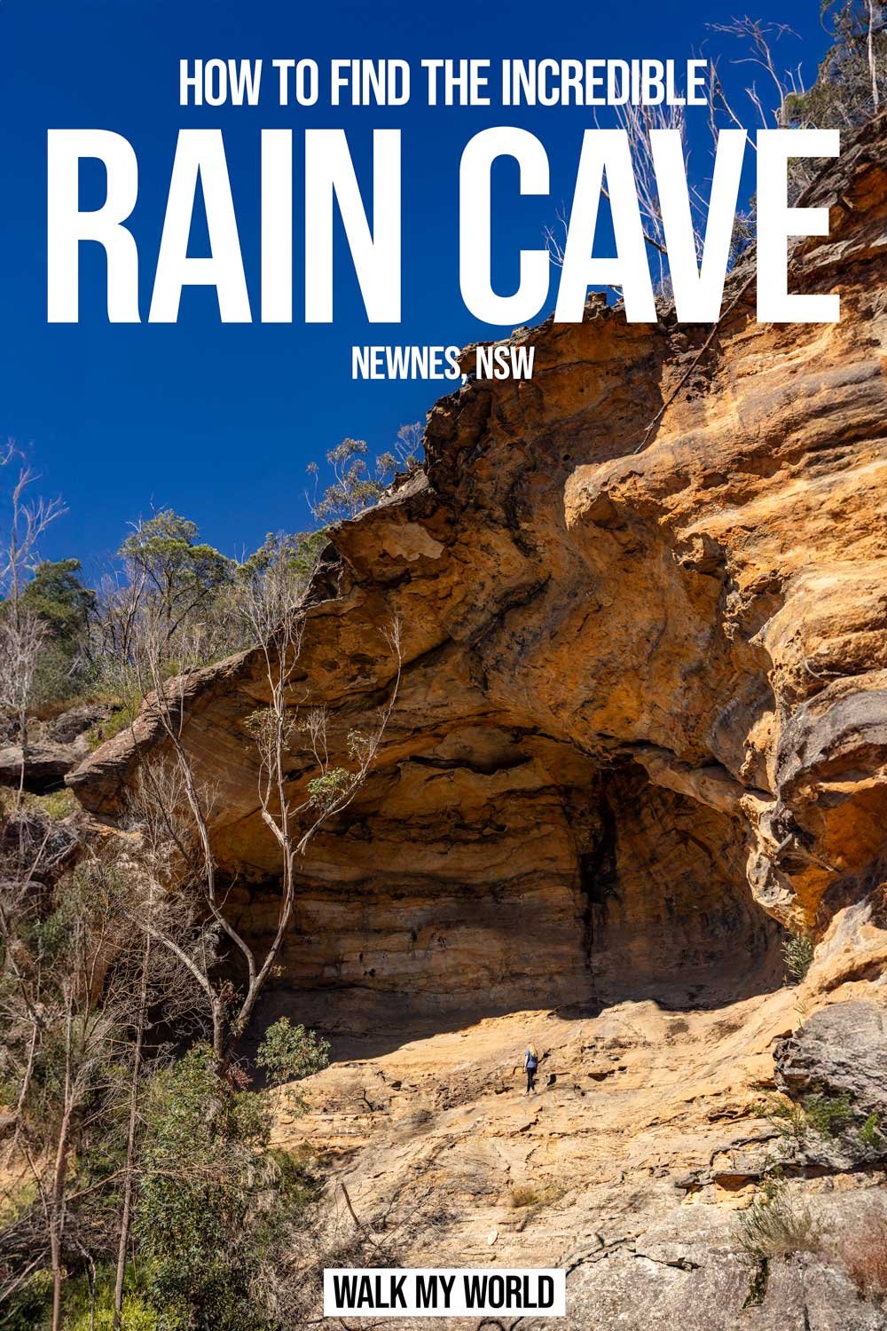
Rain Cave is a huge sandstone overhang hidden in dense bushland off Glowworm Tunnel Road. When you climb up into the cave you feel completely dwarfed by the sheer size of it. The view out to the nearby pagodas only adds to the dramatic scene. There was no sound to be heard, other than that of water dripping down the cave wall and two lyrebirds that appeared to be competing for who could produce the most unique calls.
The walk to reach the cave is short, but for the most part a bush bash. If you love that sort of thing there are many, many other caves nearby, but for us, we were happy simply to experience the majesty of Rain Cave.

The walk to Rain Cave
The stats
Distance: 2.4km return
Elevation gain: 83m
Difficulty: Moderate - some serious bush bashing on a slope
Summary: Whilst the walk to Rain Cave is only short, the 300m section that is off track is steep and very overgrown. Whilst there is a worn trail of sorts it doesn’t last the whole way and is very rough. It’s a proper bush bash where you ideally want trousers to stop your legs getting scratched.
The soil can be loose underfoot and I was grabbing onto various trees on the descent. Climbing up into the cave however is easy as it’s so grippy, so once you’ve done the rough track you can enjoy the cave without any further tricky terrain.
Overall, this track requires care and as it is remote and little visited, we don’t recommend going alone unless you are carrying a PLB. We always carry a PLB in this part of Newnes, as there generally isn’t any phone reception (we got the GME off Amazon, you can check this one and others out by clicking here). We’d also recommend having an offline map with you.

Starting the trail: along the fire trail
From the point you leave your car (coordinates below) you head onto the fire trail, which is fairly flat and leisurely (it’s called Secret Crag Road on Google Maps).
After heavy rain it can become quite waterlogged with giant puddles, but you could always skirt round the edges. After 450m you will reach a large clearing on the right, which is where you need to turn off onto the worn track.


The path is obvious here, flat, easy and barely overgrown at all. I wondered at this point if this was to be one of the easiest off track walks we’ve done lately. Alas it wasn’t to last!
You will see a cairn 150m after the turnoff, but this was the one and only cairn we spotted on the trail!

The rough descent
As you continue along the worn path it does get a bit more overgrown, but not at foot level, so the path is still always clear.
There is a tree down over the track, but nothing that’s difficult to manoeuvre around, just watch for snags that might catch on your boots.

At roughly the 900m mark is where things get tricky, and you need to turn off the relatively worn path into the bush on your left. This is not an intuitive turn because the much nicer worn path continues on.
The aim from here is to reach the gully that lies between the cliff walls leading to the overhang before Rain Cave. Before you turn, enter the co-ordinates for this gully: -33.2896306, 150.2255597 to help give you some extra guidance.

The gully to aim for
Whilst it’s not perfect, you can find a slightly worn trail at the 900m mark, and for about 150m it isn’t too bad. It’s overgrown, but it’s nothing like what’s to come.

At the 1.05km mark things get harder as the trail pretty much disappears and you are now on a slope, going downhill through the bush. It only lasts for 100m (ish), but it’s slow going.

Keep heading towards the co-ordinates on the route that looks easiest to you. Some people will head straight down the steepest route, but we traversed left a little where it felt shallower.
Take a lot of care as there are fallen branches inbetween the dense bush and the ground is often loose underfoot.


At the 1.1km mark you will see a rock platform to your left and a pagoda to your right, with a gully between. The gully is jammed with fallen trees that you will have to climb over, but once you are over this point things get a lot easier.

The coordinates for Rain Cave are -33.2902513, 150.2256304 so that’s what you’re aiming for next.
The final stretch to Rain Cave
Once you’re over the treefall you’ll see a much nicer track that isn’t overground. It is still steep for a short time, so take care once more, but it’s obvious where to go.

The trail heads downhill for 80m to a big overhang and Rain Cave is now just around the corner.

To get to Rain Cave walk through the overhang and you’ll round the corner to see a short dirt track leading uphill.
It’s damp from the trickle off water that runs down the cliff wall, but it’s still easy to get up to the cave and only takes a minute.

Exploring Rain Cave
You’ll see the giant gaping mouth of the cave ahead and though it looks slightly steep from below, the grippy tiered ledges make it easy to get into.
It takes less than a minute to climb into the mid section of the cave, which is a good point to sit, relax and enjoy the views. You can climb right the way into the top corner of the cave too, and you’ll notice lots of climbing bolts here.

You can also traverse to the other side of the cave along the middle section easily enough. I watched Joe walk across first and it’s when you get the perspective of another person inside the cave that you really feel how big it is. It’s an incredible spot and very atmospheric.

It’s a great place to relax, as there are plenty of ledges to sit on and you’re shielded from the sun and the worst of the wind.


It has a remote feel, the sort of spot you can’t ever imagine bumping into anyone! When you’ve finished exploring the cave you could visit other caves and rock formations in the area, but that one short bush bash was enough for us and we simply retraced our steps back to the car.
It was easier getting up the steep track than down it in my opinion, though still scratchy and tedious!

If you want to explore other places in the area, but prefer to stick to better paths, you could easily combine a visit here with Dry Canyon or the Glow Worm Tunnel, which are both located along the same road.
Keep them wild
Please remember to take all rubbish with you and keep these places wild and pristine - as with anywhere in the outdoors. It’s important to leave them exactly as you found them so they will remain beautiful for generations to come.
Litter tends to breed litter, so if you do spot any and are able to pick it up and dispose of it outside the area, it will go a long way to keeping the area clean.
Getting to the trail head for Rain Cave
There is no car park for the trail to Rain Cave. You need to park at these coordinates -33.2903291, 150.2331510 which is directly on Glowworm Tunnel Road in the Gardens of Stone Conservation Area in Newnes. Please pull fully off the road. Glowworm Tunnel Road is unsealed, but was well graded on our visit and suitable for any car to drive. Conditions vary on this road, particularly after heavy rain, so check with the parks service if you have a small car and are worried about the current state of the road.
The parking area is roughly 28 km and a 30 minute drive from Lithgow and 63 km and 1 hour 10 minutes from Katoomba.
This post may contain affiliate links, meaning at no additional cost to you, that we will earn a small commission if you click through and decide to make a purchase. This helps towards the costs of running our website. Thanks for your support.