

I’m going to call it right from the off: this is one of the best short walks in NSW. The scenery is spectacular, the vibe wild and remote, and there is absolutely no filler. Well there’s a teeny tiny bit of extra fire trail you’ll have to walk if you aren’t a very confident off-roader, but you can forgive that when the rest of the walk is just so good.
From crazy pagoda rock formations to a cool slot between giant cliffs, a valley full of ferns and even a little canyon grotto, you hike from one wow to another.
There is plenty more to explore in this area, but if you’re after a short action packed circuit, then you will not be disappointed with this one.
Here’s everything you need to know about the Valley of the Dinosaurs and Ultimate Slot hike.

The Valley of the Dinosaurs and Ultimate Slot Circuit
The stats
Distance: 6.2km circuit
Elevation gain: 290m
Difficulty: Moderate
Summary: The vast majority of this circuit walk is easy, though there are one or two short steep sections. Only one of these had some loose soil and was a touch slippery, the rest of the walk was on good terrain.
Depending on whether you have a 4WD and how confident a driver you are, you can park even closer to the trailhead than we mention in the notes below - we’ll mark where this is in the trail notes.
None of the walk is signposted and though you will initially have phone signal, you will lose it once you head into the valley.
We’d recommend having an offline map downloaded and we will also mark the relevant turns in the track notes. This is a remote area so you might want to consider carrying a PLB.
Starting the trail: where to park and reaching the trailhead
Where you start the trail will depend on your car and your confidence driving steep unpaved roads. We have a 4WD, but didn’t feel comfortable when the road became very steep (in fact we tried to do it and then had to reverse down the steep road for 500m!)
There is one part of the road which is quite challenging, where there are two hairpins bends on a very steep section that has an exposed drop to one side.
After this the road becomes even steeper, so we’d only recommend driving to the furthest parking point if you are very comfortable with off-road driving.
You can still go quite far along the road if you have a 4WD but want to avoid the hairpin bends and steep section (this is what we eventually did!). The parking point for this version of the trail is just off the road on a tight corner at these coordinates: -33.1204430, 150.0509602. There’s enough room for a couple of cars to park here. To get to this point still requires driving up a steepish section of dirt road, but it’s not challenging.
If you think you can take on the difficult road, then you can continue beyond this point for a further kilometre.
If you only have a 2WD you will need to park earlier and walk the road. Full details in the parking section below.

If you park where we did, you will walk that last kilometre of the road, the first 750m of which is uphill. It’s pretty steep, but I preferred being on foot to in the car! At the 750m mark the road will flatten and reach the closest parking area to the trailhead 250m later. You will have gained 90m elevation over the kilometre.
If you do drive it instead, make sure it’s a dry day and be mindful that the road surface is loose in places. It’s totally doable if you’re good on 4WD roads, but probably a bit hairy if you’re not very experienced like us.

Finally, it’s worth noting that the road is only one lane wide in parts and there’s rarely any room to pass, it’s not a busy road by any means, but it’s something to be mindful of.
Finding the pagoda lookout
From the final parking area, continue for 100m along the road and you will come to a signpost for Genowlan Trig. Follow the signpost right, heading quite steeply uphill.

Technically this is still a fire trail, but it’s rocky and there’s nowhere to park at the turn off, so you do need to walk this bit.
Roughly 150m from the signpost you’ll see a small pagoda which you can walk onto for a good view - though it’s nothing on what’s to come.

You’ll continue heading steeply uphill for another 200m before the gradient slackens. It’s gentler for another 250m before it steepens again.
Just before the road curves you need to look out for a small cairn, the coordinates for the cairn are -33.1163309, 150.0557669.
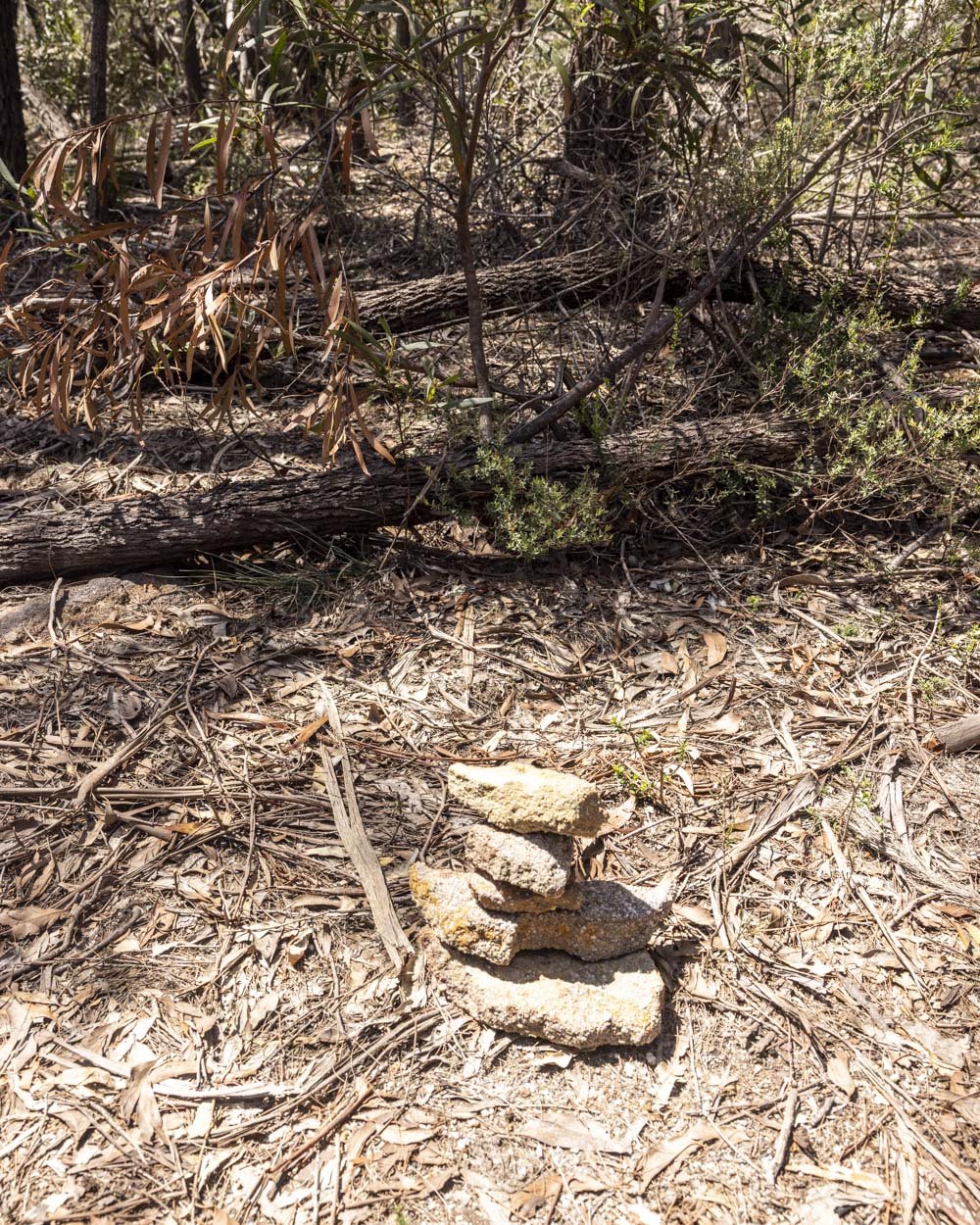
Unless this trail becomes a lot more trodden down, there will be no obvious path here, you just need to trust the cairn and the coordinates and head into the bush here.
Though there is no set path, the bush is easy to walk through and you’ll be heading slightly downhill for 150m before you then need to bear left. Everyone will walk this section slightly differently, but with the coordinates you shouldn’t have too much trouble.


After bearing left, you will see a small pink ribbon tied to a tree. Follow the path straight on past the ribbon and into more open terrain. You’ll see a large rocky area ahead, 50m from the ribbon (200m ish after the cairn).

Traverse this rocky pagoda and you will pick up another worn path heading between the scrub. You are 100m from the Pagoda Lookout now and the path should be obvious, but for reference the coordinates are: -33.1146885, 150.0568777.
The Pagoda Lookout
Even if it weren’t for that particularly striking rock formation, this viewpoint would be spectacular. The dense pagodas and sheer cliffs make for one incredibly dramatic scene. It’s definitely a wow factor view and there is plenty of space on the grippy (when dry) rock formations to take it all in.


However, it’s that one stand alone rock formation that has become popular on social media lately. It’s a couple of minutes walk from the first pagoda you’ll come to.

You can walk alongside and then up the back of the rock formation where there is a shallow route up on to the prominent pagoda. It steepens as you get closer to the the spire.
The rock is extremely grippy when dry and there are obvious footholds to climb the rock, however, I do not recommend standing on top of it.

One unexpected slip of the foot would be an absolute disaster here and it’s really not worth the risk. I know people do it, I just wouldn’t personally.
I stood on the ledge with the pointed bit of rock acting as a barrier, which for me felt fine, but wouldn’t be recommended if you suffer from jelly legs.

I was also fine sitting on the rock, but not with legs forward to the main view as this falls into the category of one slip and you’re gone. Though photos make this spot look far edgier than it really is, don’t take any risks as it really isn’t worth it.
Entering the Valley of the Dinosaurs
Distance from Pagoda Lookout to the fire trail at the end of the Valley of the Dinosaurs: 1.3km
Coordinates for the entry: -33.1158319, 150.0562281
To get into the Valley of the Dinosaurs, you need to walk down into a gully from the northern side of the gully. Luckily the entrance has been marked by that pink ribbon that you saw on the way to the pagoda lookout.
From the pagoda lookout, retrace you steps back for 150m to that pink ribbon. Now bear left and you’ll see a small red ribbon tied to a tree, followed by another ribbon soon after.

After just 50m you’ll see the opening into what looks like a gorge and will see a sharp right turn at another red ribbon.

Taking this sharp right gives you a much more shallow entry to the gap between the cliff walls and it’s nice and easy (this right turn is just a few steps away from where you could take a steeper route down).
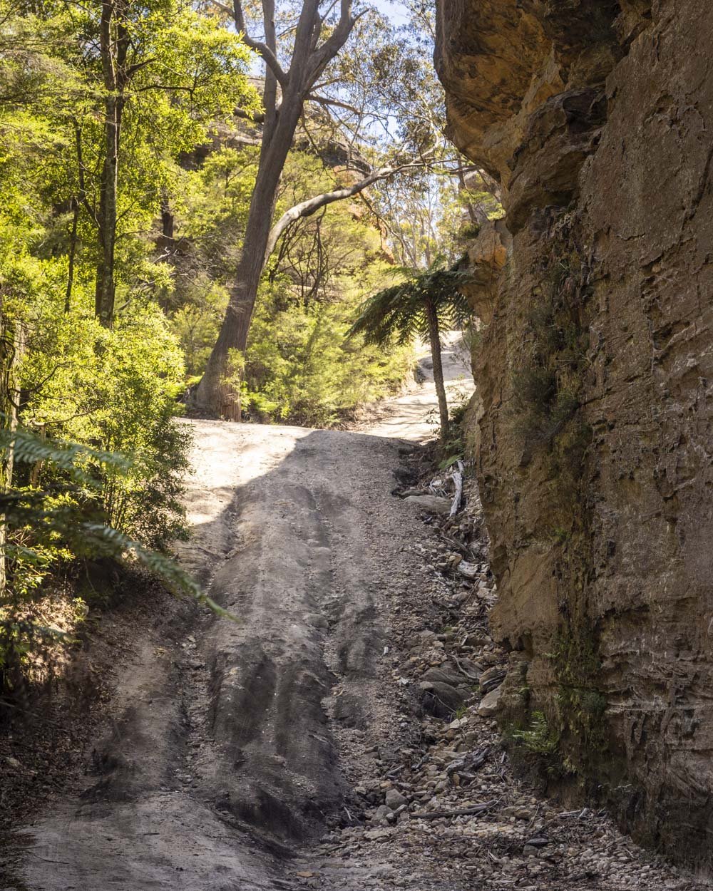
The first few steps downhill are quite steep before it slackens and the terrain underfoot is pretty good. There are a couple of logs to walk over, but nothing more challenging than that.

Just after you leave the cliff walls behind there’s a large tree down over the track, but it’s easy to climb over. The track will now begin heading more steeply downhill.


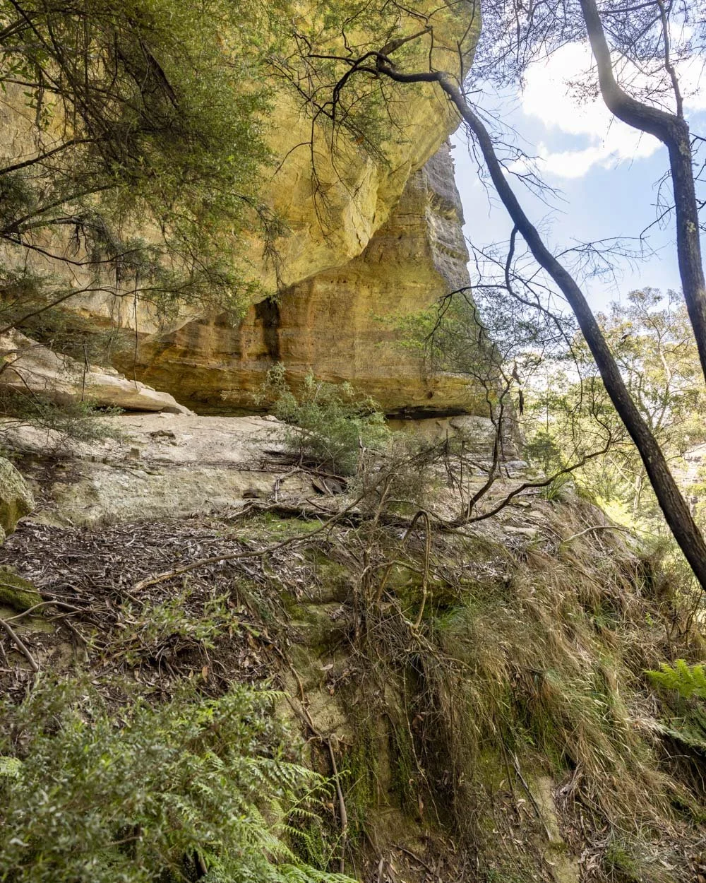
There’s an overhang you can have a look at 40m after the fallen tree and it’s from here, as you head into the valley, that you’ll have a short steep section of loose soil.
From my notes it looks like it was only 20m, but it felt a bit longer than that. It’s my least favourite kind of terrain and the only bit of the walk that I didn’t really like, happily it was very short! The scenery is gorgeous with high cliff walls and tree ferns galore.
The Valley of the Dinosaurs
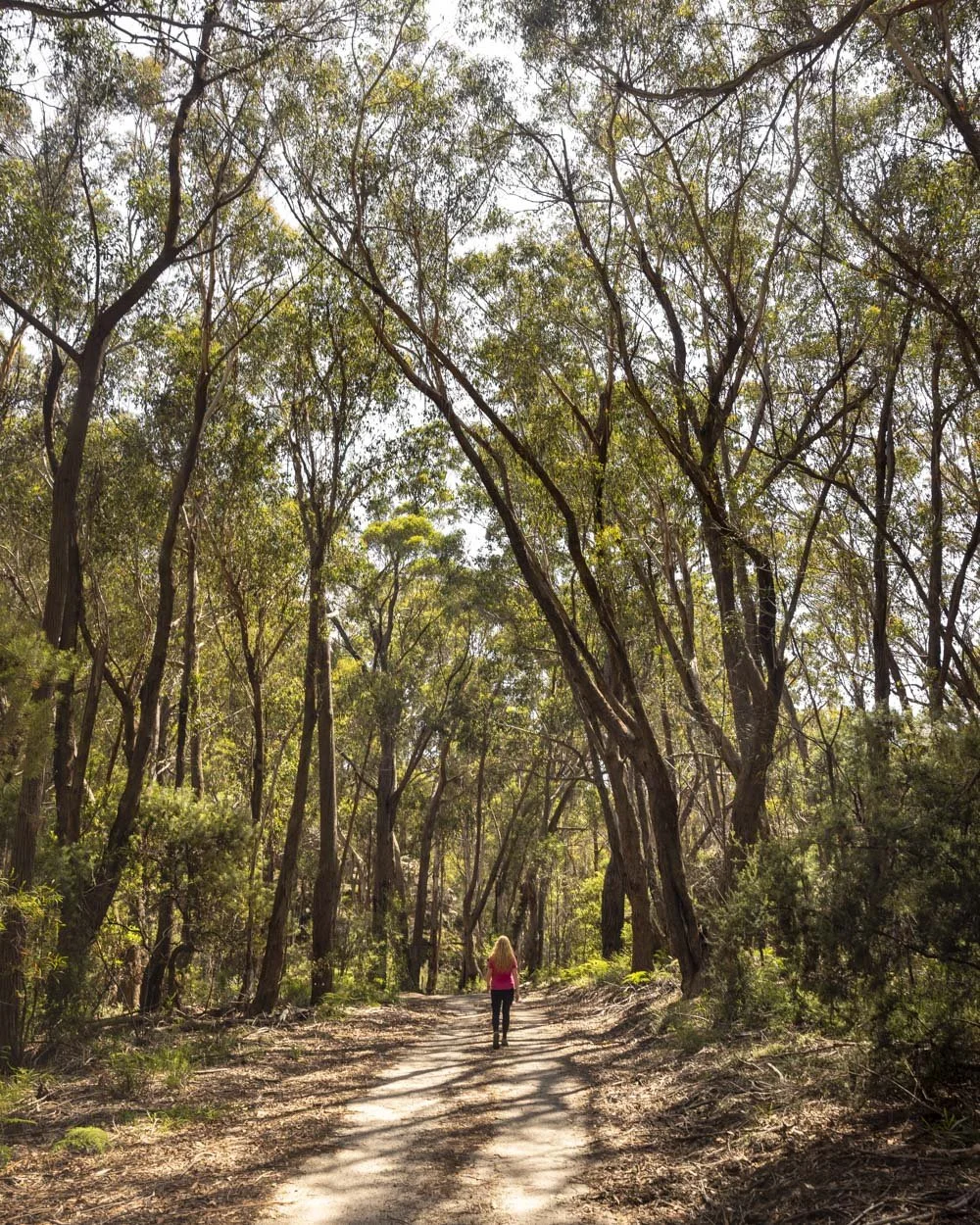
After that short steep section, the trail all but flattens and and the route is marked with intermittent red tags. To be honest the path is almost always very clear so you don’t really need them, but they’re good to reassure you you’re still on track.
You’ll begin walking between a sea of ferns, sometimes they were as tall as me and though it can feel a touch overgrown, it does add to the wild remote feel. And yes it does have those Jurassic vibes!

The path is either flat or gently downhill and apart from the fact it’s sometimes obscured by ferns, it’s easy and you can really take in the fantastic views.
The cliff walls and tree ferns are incredible and you feel very far from civilisation - in a good way!

A couple of hundred metres into this ferny section there is one right turn which is easy to miss and leads you to walk beside an overhang.
Roughly another 100m away is another right turn by some significant tree fall. They’re not overly obvious, but if you know to watch out for them you won’t miss them - and it’s just an easier path, you could still get through the ferns but they get denser.

Around 150m after the tree fall, the path heads a little more steeply downhill, but it’s not difficult or slippery. The worn path is easy to follow for another 250m or so before it becomes more indistinct.
The trail bends left and is marked by a white ribbon tied to a tree. It curves right 30m later.


You then have 170m before you pick up another ribbon and the path is much less obvious than it’s been to now. However, we did have a GPS fail here and still found the next ribbons (two pink ones tied to two trees which are very close together).

This path then brings you out to the fire trail 50m later.
Locating Ultimate Slot
Coordinates for the start of the trail to UItimate Slot: -33.1107310, 150.0553298
Coordinates for Ultimate Slot: -33.1123863, 150.0554053
When you exit the Valley of the Dinosaurs you will head onto a fire trail and turn left. Follow the road for 150m and you will see an unmarked but obvious path on the left.

This is the turn off to Ultimate Slot, which is 250m away. The path is very easy to follow and the track conditions are good. It’s a dirt track with some rocks and tree roots, but nothing tricky to contend with.
There’s a very slight climb up to the entry to Ultimate Slot and as you get close, the trail narrows and the temperature noticeably drops.


The entry is impressive in itself, with a giant but very narrow crack between the cliff walls, which reminded me a little of Split Rock at Deep Pass.

The Ultimate Slot
You can squeeze through the narrow opening and it leads to what almost feels like a chamber. It’s 50m from end to end and has a mysterious air to it.

There’s a weeping wall at the very end and there were no other sounds but that of the dripping water, which made it even more atmospheric.

We visited on the sunniest of days and the slot remained very dark. I wondered if at a certain time of day it might get a light shaft through the narrow crack, or maybe the walls are just too tall?
It’s a really fun spot and adds yet another unique feature to this short walk.


Continuing to the mini canyon grotto
Coordinates for the trail to the mini canyon grotto: -33.1105494, 150.0553458
The final part of the walk takes you to a small, but very pretty canyon. To find it, head back to the fire trail and walk right, back the way you came for a few metres and you will see a very obvious path on the left.
Follow this path and after 10m you will see the remains of a rusted old set of railings beside an overhang.


Finding the railings was so unexpected, we didn’t know this area used to be a tourist attraction, but clearly it was! Who knows how old the railings are, so I wouldn’t necessarily lean on them too heavily though!
Follow the overhang round (which is easy without needing to use the railing) and you’ll come to a narrow ledge above the canyon.
The railing continues all the way along the ledge, which is nice and grippy when dry. Footing is easy enough and after a few metres there is a little ladder down into the canyon (just a couple of rungs and it felt very stable).

You’ll then be standing inbetween the sculpted walls of the canyon, which is incredibly picturesque. Sadly it only lasts for a few minutes, but it’s beautiful and not something we were expecting to see on the walk.


At the end of the narrow canyon you can climb up the small cascade (easy to do) and continue for 30m to a small waterfall grotto.

You’re surrounded by tree ferns and it’s a lovely spot, though with more water it would be even better. This 30m stretch of ‘track’ is easy, though watch for any wet bits of rock which could be slippery.
We then retraced our steps back out of the canyon, though I didn’t climb down the cascade just incase it was slippery on the way down. Instead I sat on the dry cliff edge to the right of the cascade and went down on my bum!

Once you’ve made your way back to the fire trail you’ll now turn right. The road will head uphill and arrive back at the Genowlan Trig sign after 350m. You’ll now either be moments from your car, or if you parked where we did, just over 1km away.

Getting to the Valley of the Dinosaurs and Ultimate Slot Circuit
The trail is located in the Mugii Murum-ban State Conservation Area, close to Capertee. It’s around 10km and a 15 minute drive from Capertee, 91km and a 1 hour 20 minute drive from Katoomba and 193km and a 2 hour 45 minute drive from Sydney.
As soon as you turn off the Glen Davis Road, the road to the trailhead is unsealed and it becomes very steep. If you only have a 2WD you will need to park earlier on at these coordinates -33.1205809, 150.0473474 and walk the road, which we estimate will add on an additional 1.5 - 2km each way. We walked a little extra too as mentioned above despite having a 4WD.
Do not attempt this road even in a 4WD after heavy rain as I think it could become very slippery.
This post may contain affiliate links, meaning at no additional cost to you, that we will earn a small commission if you click through and decide to make a purchase. This helps towards the costs of running our website. Thanks for your support.


