

An easy walk-in canyon with huge sandstone walls that nobody seems to talk about? It sounded right up our street! Whilst well known to canyoners, I’ve never seen a hiker mention Joe’s Canyon, yet it’s a truly fabulous walk that’s both easy and spectacular.
Every few steps through the narrow constrictions had me shouting back to Joe that it was getting better and better. It really is a beautiful canyon and the dramatic sculpted walls make you feel small in the best possible way.
Here’s everything you need to know about visiting Joe’s Canyon.
The Joe’s Canyon Walk
The stats
Distance: 6.5km return, or a 9.8km circuit (involves significant wading and a boulder scrambling section)
Elevation: 320m
Difficulty: Easy, but quite a few stairs to climb on the way back
Summary: If you complete Joe’s Canyon as a return walk, it’s an easy track with low water levels for the majority of the way (assuming there hasn’t been recent heavy rain). Most of the water is at ankle height, with a couple of knee deep sections and one very, very short bit which was between the knee and waist.
The track to reach the canyon is well maintained and well signposted. There are some flat sections, but a fair amount of the walk is downhill on the way, so there’s a decent climb back up to your car. We found footing was generally very good inside the canyon and we didn’t encounter any slippery bits, though care should always be taken.
There is one section where there is quite a bit of debris inside the water, and the path that bypasses it is narrow and has one short loose section, but it’s only a very short stretch and not too challenging.
If you’re looking for a bigger adventure, you can also do a more challenging circuit route, that involves swimming and wading through two creeks before exiting at the Wollangambe River. We’re covering this in a separate guide or this one will become too long and unruly!
Starting the trail
From the Mount Wilson Fire Station (full parking details below) there’s a short dirt trail that joins the Merewether Fire Trail heading north, following the sign for the “Wollangambe Walking Track”.

The wide flat path runs between gorgeous tree ferns for the first 250m. You’ll then reach a sign mentioning that gear is required (this is for the Wollangambe Canyon, not Joe’s Canyon).
You’ll head left here, following a wide fire trail uphill for 400m. You will pass many more warning signs for the Wollangambe River along the way.

The track will then briefly flatten before heading downhill. You’ll reach a signposted junction 150m later and head right.
Roughly 70m further along you’ll reach another signpost and head left, following for the Wollangambe River.
The track now narrows and though the path underfoot is always clear, some of the plants do encroach a little making it a bit scratchy.


The good dirt path continues downhill, with the occasional flat section before reaching a series of stairs, at around the 1.6km mark.

Descending to Joe’s Canyon
When you reach the stairs you’ll see another signpost (though Joe’s Canyon is not always on the signposts) at first you follow the same trail as for the Wollangambe River.
After 500m you’ll start to get some big open views and the trail curves right, beside a pagoda (just over 2.1km into the trail). After another 50m you’ll see a signpost and head left, following for the Wollangambe River.

There’s another large pagoda beside the trail and you’ll pass alongside it on a brief rocky section of track before it’s a smooth path once again.

After 400m very easy walking you’ll see a sign for Joe’s Canyon and follow it left.

There are a couple of trees down over the track, but they’re very easy to step over and the final 200m to the start of the canyon are very gradually downhill (you’ll reach the start of the canyon walk 2.8km into the trail).

Through the creek
Entry to the canyon is via two little dirt steps directly into the creek. At first the rock walls are quite low as you’re not in a narrow slot yet - it’s more of a creek walk.
As mentioned, the water levels are generally low. For us it was mainly ankle height and any deeper sections were very brief.


The water is cool, but wasn’t freezing in summer, however, if you’re walking in winter and you really feel the cold, you might want a pair of neoprene socks.
There are a couple of logs to climb over, but it’s easy and even this early part of the creek is pretty. After 50m there’s a bit of a log jam, but you can skirt the side of it using the track along the river bank to the right.
You’ll then continue in the creek a little longer, where it’s shallow but for a couple of steps through one deeper section, which was quite a bit above knee height (but below the waist).
This was 120m into the creek walk and may have been avoidable with a scramble to the right, though I went straight through it, so I can’t be sure.

Just past this short deeper bit there is quite a bit of debris in the water. It’s easier to use the path on the right, along the riverbank, to bypass it. It’s generally in decent condition, but a touch narrow.
You can re-enter the creek around 80m later. It’s a few steepish steps back down to the water, but quite stable.
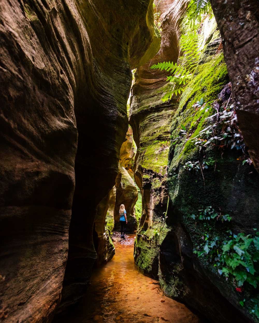
You’ll then be standing in front of some huge rock walls and this is where the spectacular canyon journey begins.

Through the canyon
After re-entering the creek, you have less than 100m easy walking to reach the first narrow constriction. The canyon walls tower above you and despite visiting on a sunny day, almost no light penetrated the chasm.
The walls are beautifully shaped, some sections are bare, while some are covered in moss and ferns.


It’s a spectacular beginning to the slot canyon and the low water level makes walking through it very easy.
The very narrow part of the canyon only lasts for around 50m, but you could spend a long time taking in all the dramatic scenery.

If you’re going to do the circuit route (and therefore not return through the canyon) make sure you turn around at various points because it’s gorgeous in both directions.


Once you reach the end of the constrictions you’ll reach a slightly more open section and see a narrow gap between the rock walls ahead.
You can either squeeze through here, or take the path on the left, which heads through a gap in the rocks. It then crosses a small pool before joining up with the other trail.

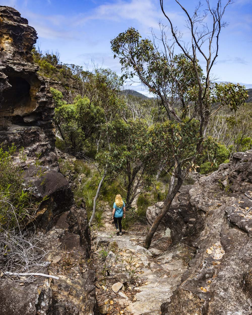
There’s another very short narrow section with a tree down that is very easy to climb over, before it opens up into what feels like a little patch of forest.
You walk up the large rock and follow the obvious worn path until you reach a big boulder just under 80m later.


You could go one of two ways here. We walked to the left up and around the big boulder using the dirt track.
To get back down to creek level (20m away) you have a little down climb of around two steps, but it’s not difficult.

You will then be standing at Du Faur Creek, with its gorgeous cliff walls and crystal clear water. If you’re not doing the circuit route this is where you would turn back.

The circuit is incredible, but it’s a much longer adventure, with an extra 3km wading through the creeks. It doesn’t sound far, but there is also some scrambling involved and several swims. We’re going to be covering the route in a separate guide.
If you are heading back the way you came, it’s all easy going terrain-wise, although there’s a fairly lengthy climb on the way back up to the car park.
Keep them wild
Please remember to take all rubbish with you and keep these places wild and pristine - as with anywhere in the outdoors. It’s important to leave them exactly as you found them so they will remain beautiful for generations to come.
Litter tends to breed litter, so if you do spot any and are able to pick it up and dispose of it outside the national park, it will go a long way to keeping the area clean.
Canyon safety
Canyons can be dangerous environments in the wrong conditions. Never enter a canyon if it’s raining or rain is predicted as flash flooding is a real risk and it can happen very quickly.
There is little to no phone signal around Joe’s Canyon, so it’s advisable to carry a PLB incase of emergency. We carry a GME personal locator beacon, which has the added benefit of working globally. You can check this one and others on Amazon.
Getting to the trailhead for Joe’s Canyon
The walk to Joe’s Canyon begins at the Wollangambe parking area opposite the Fire Station in Mount Wilson. You’ll find plenty of free parking in the designated car park. It’s around 40km and a 40 minute drive from Katoomba, 32km and a 30 minute drive from Bilpin and 122km and a 2 hour drive from Sydney.
There is a public toilet at the fire station, but nowhere else along the trail, please plan accordingly.
This post may contain affiliate links, meaning at no additional cost to you, that we will earn a small commission if you click through and decide to make a purchase. This helps towards the costs of running our website. Thanks for your support.


