

Looking for a walk with epic ridge lines, easy scrambling and glorious views over Snowdon, yet still avoids the crowds? Yes, it’s possible and you’ll find all of that and more on the Nantlle Ridge track. Despite walking in perfect conditions on a summer’s day, we saw just four other people! For the rest of the time it was just us in the wilds of Snowdonia.
There are a couple of steep climbs, but no technical terrain. The scrambling can be easy or more challenging depending on which route you take. This makes it a good option for practicing your scrambling skills, without the exposure of some of the more famous peaks.
Here’s everything you need to know about the Nantlle Ridge walk.

The Nantlle Ridge Walk
The stats
Distance: 7.8 miles (12.6km) circuit
Elevation gain: 825m
Difficulty: Hard
In typical Snowdonia fashion, the Nantlle Ridge walk has plenty of climbs, including one steep one. Whilst the majority of terrain across the track is good, the first climb to Y Garn has some loose rock which can be a little slippery (even when dry) along the steepest section.
When it comes to the scramble, you can avoid most of it (details below) and the bits you do need to do are not exposed. You can make it more challenging if you want though, so it’s great for everyone (although it’s not a long scramble like you’ll find on some other tracks).
The descents are steep, but for the most part not too slippery when walked in an anti-clockwise direction - I personally wouldn’t want to descend Y Garn.
Almost the whole walk is exposed, so ideally you want a day with low wind and no rain as the path conditions will be much more challenging when wet. There are no signposts for the walk, so you’ll want to download an offline map, we’ve also included directions below.
What to expect on the trail
Starting the trail at the Rhyd Ddu car park
The first 800m of the walk are a leisurely stroll; enjoy them because after that there’s a significant amount of climbing before you’ll get some respite again!
You’ll start on a flat gravel path heading over the small bridge, and then take a right 50m later (300m from the car park).

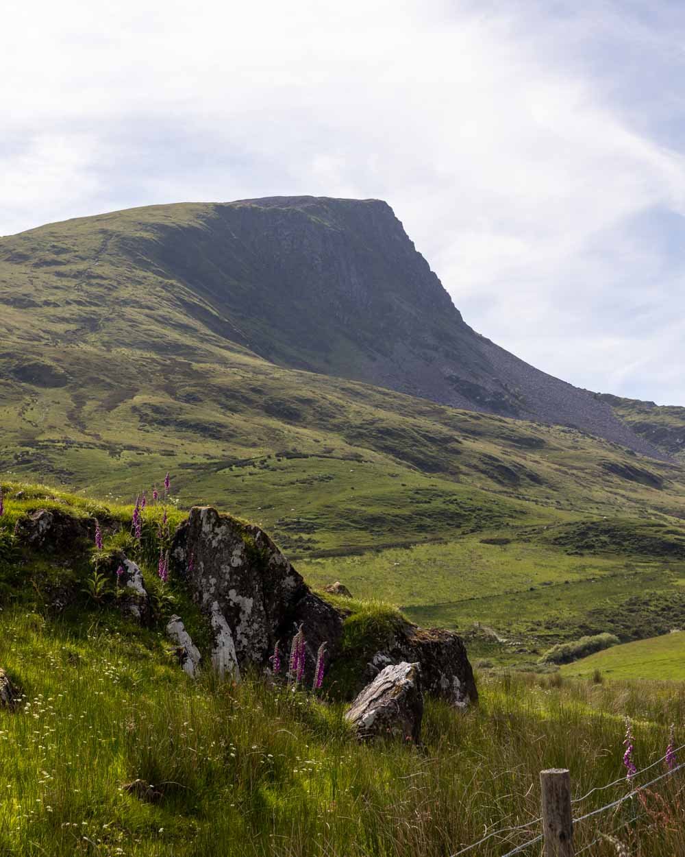
A couple of hundred metres later you’ll head up a couple of stairs and then turn left through the gate. The views are already good, and Y Garn looks quite imposing.
After passing through yet another gate at the 800m mark, the climb begins. You’ll start on a dirt path, which turns into a grassy path with footholds worn into the dirt.
After 500m you’ll climb over a stile and marvel at the views behind you, which are already stunning and include Snowdon.


Getting to the top of Y Garn
There are a couple of muddy patches along the track, which were no issue for us in dry conditions, but could be a little slippery if it’s wet.
As you climb higher, the path becomes narrow and rocky, but it’s generally a good ascent, steep but stable.

However, after another 400m the stones get a bit loose and even when dry, some bits were a little slippery - I definitely wouldn’t have been happy descending this track!

Luckily the steeper parts with loose rock don’t last too long and are mixed up with easier terrain. At the 2.6km mark, you’ll reach a boulder field and the gradient is now quite gentle.
The easiest way through the boulders is to keep left before curving right, which takes you to a stile 250m later. This route only traverses a few boulders and is therefore quite straightforward.


After climbing over the stile you now have just 100m more ascent before reaching the cairn that marks the top of Y Garn, 3km into the walk.
The views are fabulous and the imposing ridge of Mynydd Drws y Coed adds some drama to the scene. We were lucky to have great weather, but there’s a rock shelter to keep out some of the wind if you need.

Traversing the ridge of Mynydd Drws y Coed
The trail continues past the wind shelter and heads towards the craggy ridge line of Mynydd Drws y Coed.
Not being an experienced UK scrambler (read complete novice), I thought the ridge looked daunting and much more difficult than I was expecting.
However, you need to get up close to see the route and realise it’s actually pretty easy.

The first section of rocky terrain comes 300m later and just involves climbing over a few rocks and boulders. There is then a further 200m of normal track before you reach the start of the scramble, which in itself is just 250m long.
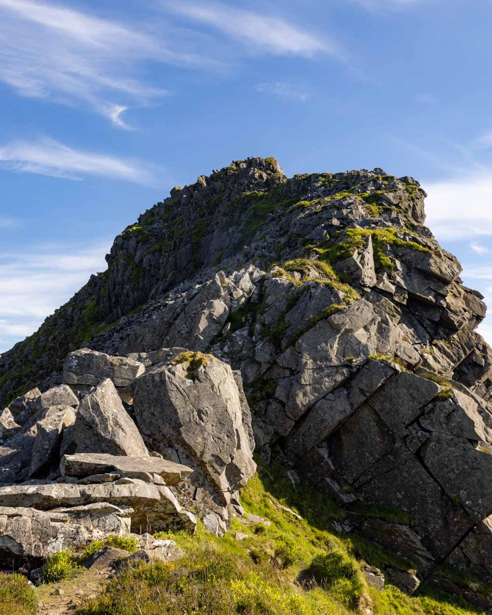
Depending on your appetite for scrambling you can either hug the left side of the ridge, which will avoid much of the scrambling (making use of small sections of path) or take the middle line which is almost a full scramble.


The great thing about Mynydd Drws y Coed is that the rocks are very grippy, and there is little to no exposure (although it still wouldn’t be one for vertigo sufferers). If you’ve picked a day with low wind - which you should if you can - it’s really fun, even for novices.
There are no tricky manoeuvres, the views are great and it adds a bit of excitement to the walk.

I personally found scrambling over this ridge easier than the steepest parts of Y Garn as it felt really stable.
After the scramble there’s 100m of track before you reach the top of Mynydd Drws y Coed (just over 4km from the car park). The views are of course wonderful, as they are along the whole ridge.

Onto the peak of Trum y Ddysgl
The next section sees you walk over a stile and begin descending on a grassy path. After a few hundred metres, the path begins heading around the side of Trum y Ddysgl, the next peak you’ll climb.
It’s a good path and nice and leisurely, allowing you to soak up the views. At the 4.5km mark you’ll see an obvious path on the right. This is where you head up to the top of the peak.


You could choose to skip this bit by carrying on straight, but I wouldn’t recommend it because the views from the top are gorgeous.

It’s just a 300m climb on a decent path, rocky in places, but easy enough, and then you’ll reach the long flat top of Trum y Ddysgl (800m from the top of Mynydd Drws y Coed).
There are views over the mountains, ridge lines and out to the Irish Sea.

Continuing to the final peak: Mynydd Tal y Mignedd
This next peak is a bit of a detour, so if you’re feeling spritely you can include it, but if not just skip it. It adds on just under 2km return, including two hills to climb, which are both quite steep.
The top of Mynydd Tal y Mignedd is a lovely spot and makes for a good rest or lunch stop, but it’s not an absolute must do.
To reach it, you head along the flat ridge from Trum y Ddysgl for a couple of hundred metres and then begin descending, following the path on the right.

After 450m down the grassy path, you’ll arrive at a short narrow section, which takes you alongside the cliff with a big drop to the left.
It’s a good gravel path and not so narrow as to feel precarious, and as you’ve just done Mynydd Drws y Coed, it’s unlikely to phase you.


It’s 50m long and then you rejoin a grassy path. Shortly after you’ll begin ascending to the trig point. It’s quite steep, but an easy path and 350m later you’ll be standing at the trig.
The far side of the trig was a good spot to stop for a break because you can lean again the rock, so you have a nice backrest to go with the fab view!
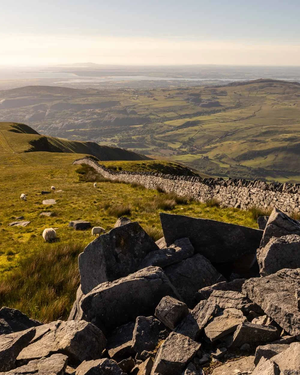

The views are similar to what you’ve seen already, but you can now see more of the mountains on the left and a small lake nestled inbetween them.
When you head back, it’s along the same path - first downhill and then back up again. After 850m, look for the path on the right, which is just below the top and cuts across to the main path and the start of the descent.

The descent begins
Physically, you would think it gets easier from here, because after a lot of climbing it’s now virtually all downhill or flat. The reality is that the first 750m of the descent are really steep, which I personally find harder than ascending!

The grassy path has worn in footholds and it’s not slippery when dry, but it’s still taxing at that gradient. It does then briefly flatten, before the descent continues - although it’s mercifully less steep. It does flatten again as you head along a narrow path on the side of a hill.
There’s a final very short steep section as you head left alongside the fence and then it gets easier. A few hundred metres before you pass through a gate (8.8km into the trail) the ground gets boggy.
For us it wasn’t too bad, a little squelchy, but nothing that would flood your boots, however, I can imagine in colder wetter times it could be pretty bad!
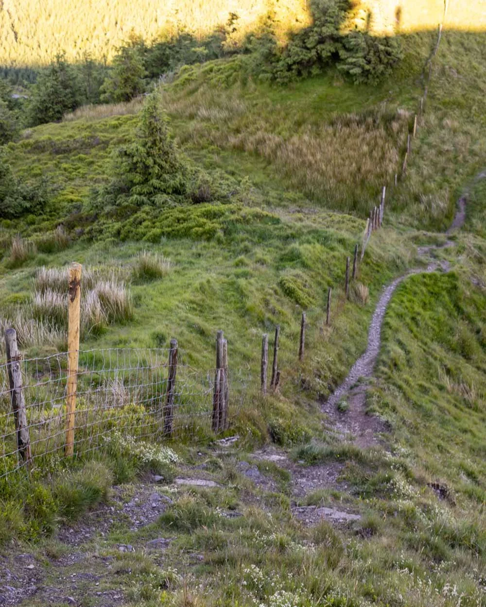

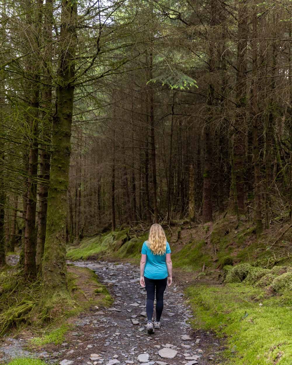
Luckily it’s not a long section and then you pass through the gate and into a beautiful stretch of pine forest.
The stony path descends through the mossy forest and though gorgeous, is a bit slippery when wet, but taking it slowly helps.
Completing the circuit
At the 9.8km mark you’ll emerge from the forest onto a gravel road. Head right and then bend left briefly downhill before the road flattens. It’s a quiet forestry road, so though it is not as scenic as the rest of the trail, it’s still pleasant enough.
There are a couple of turns to make (always following in the direction of north north east) and at the 10.1km mark you’ll see a footpath heading gently uphill on the left.

It soon flattens and the gravel track takes you through a pretty stretch of forest. After 350m you’ll leave the forest and come back out into the open again, where you’ll get some terrific mountain views, which include Snowdon.

The narrow gravel path is a delight, with stunning views every step of the way and the flat track means it’s a leisurely stroll.
You’ll come to a small waterfall you cross over on a couple of handily placed rocks, before the trail descends again, but gently this time. The views of both the mountains and lake are breathtaking.


After just over 1.1km on this lovely section of track you’ll rejoin the original path you came in on, and follow it all the way to the car park, which is now 800m away.
It’s straightforward, but it is easy to miss one turn which will take you into private land, so keep and eye out for the exact path you came in on.
All in all, this walk is a Snowdonia must do. It’s hard to believe how quiet it is, yet it doesn’t compromise on fabulous views and interesting terrain.
Nantlle Ridge trail head car park
The walk begins at the Rhyd Ddu train station car park. It might be the start of a route up Snowdon, but it’s not a popular one, so you should be ok for parking on all but the busiest days. The car parking fee is £6 for the day. There was a lower fee (£3) for four hours, but that would be tight unless you’re a really fast walker. The machine takes card.
The car park is a 20 minute drive from Caernarfon and 40 minutes from Betws-y-Coed, and there are toilets at the car park.
This post may contain affiliate links, meaning at no additional cost to you, that we will earn a small commission if you click through and decide to make a purchase. This helps towards the costs of running our website. Thanks for your support.


