

As you drive towards Betws-y-Coed your eyes are drawn to the imposing sight of Moel Siabod looming ahead of you. If you’re a keen walker, you’re automatically going to want to climb it, and you won’t be disappointed when you do. The views are incredible, the trail varied, and there’s the chance to scramble if you want to.
The ridge lines and mountain scenery are some of the prettiest in Snowdonia and you get into the thick of it quite quickly.
Here’s everything you need to know about climbing Moel Siabod.

The Moel Siabod Walk
The stats
Distance: 7 mile (11.2km) loop
Elevation gain: 750m
Difficulty: Hard
There are various routes you can take up Moel Siabod. The route we’re covering is a circuit, with the option to scramble up Daear Ddu (grade 1) if you like, but you can also avoid the scrambling in its entirety.
Part of the walk has well formed paths, but there are also short sections of boulder hopping and some rocky track (although again the rocky section could be avoided). The descent via the rocky track does get rubbly and a little slippery towards the end.
There is a significant amount of uphill on this walk and very little flat sections. However, there’s no exposure anywhere, so you can stop often.
Signposting on the route is non-existent, but it’s pretty easy to navigate in good conditions. We have included full directions in the trail notes below, or you can download an offline map.
The route is exposed to the elements, so it will be much nicer on a day with low wind. You also want to pick a dry day, or parts of the trail would become very slippery.
Starting the trail at the A5 layby
From the lay-by (details below), walk for 100m along the road and then head left. Roughly 150m later you’ll see a road on the right heading uphill - it’s easy to miss it if you’re not keeping an eye out.
You’ll then be heading uphill on a sealed road, surrounded by plenty of pretty greenery, so it’s not too much of a hardship.


After 400m you’ll see a handwritten sign saying ‘path’ on the left, from here you’ll leave the road and start heading up a gravel path surrounded by bracken.

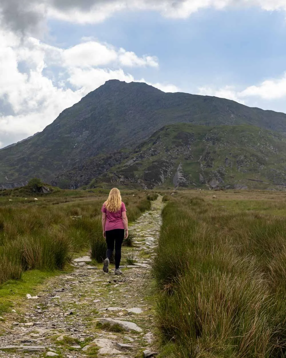
The path flattens all too briefly and you’ll come out to farmland backed by gorgeous mountains. Keep heading uphill along the gravel road and over the stile.
From here you’re walking uphill, on a stony path through farmland. You’ll see Moel Siabod ahead of you and it looks like quite the climb from here! The gradient of the trail along this section becomes more gentle and navigation is easy - you can also see where you’re aiming for.
To the lake and quarry
The trail continues ascending up to the 1.9km mark, when you pass through a gate and briefly descend on a good gravel path. From here the scenery goes from pretty to absolutely gorgeous.
You’ll head along a stony path with a small lake on one side and jagged cliffs on the other. This is the moment I was so glad that despite walking Nantlle Ridge the day before, we made the effort to get out again.


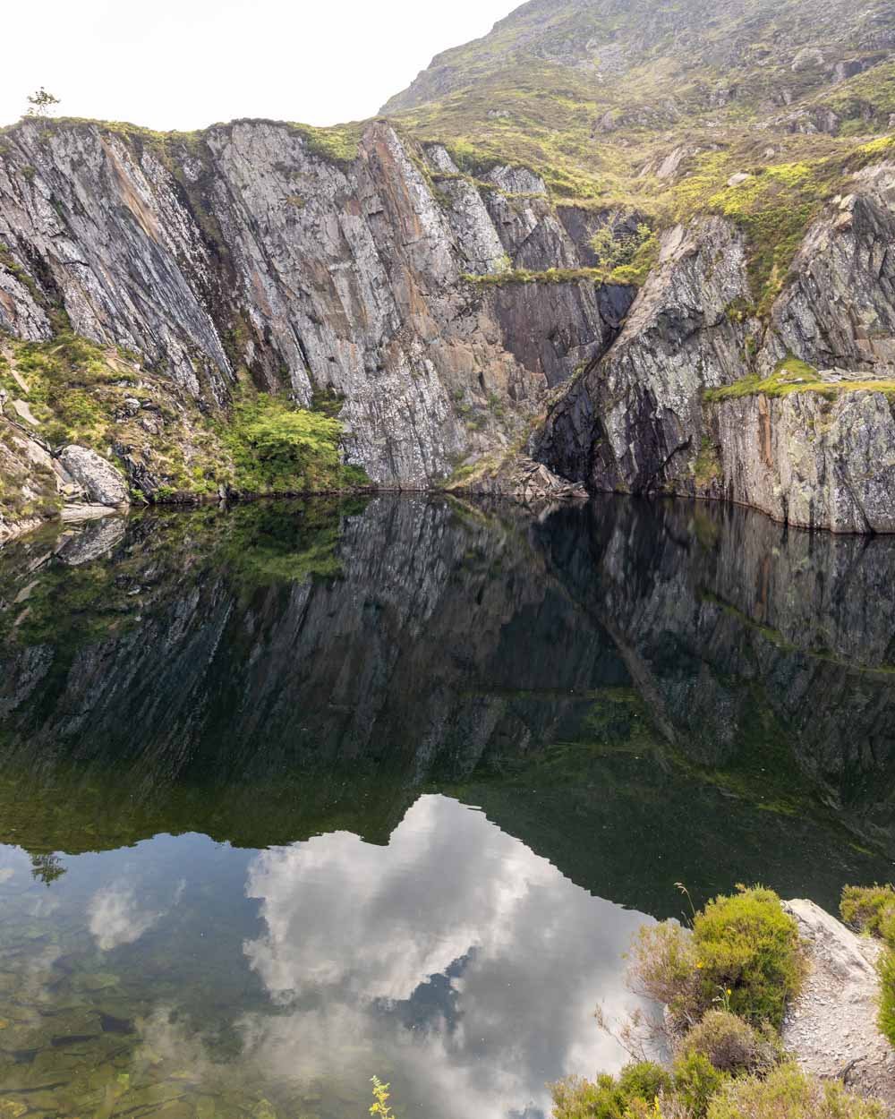
After ascending for a few hundred metres, you’ll pass the remains of an old mine site, including some huge slate piles.

You can veer slightly off the path to take a closer look at the ruins. Just beyond the slate piles you’ll arrive at Rhos Quarry, which has filled with water to create a beautiful lake.
On a calm day the reflections are stunning and the water colour has you wishing to go for a swim. I’d never thought of quarries as something that could be beautiful until arriving in Snowdonia and seeing places like this!

The views are fabulous in every direction and as you continue climbing up around the lake, you’ll constantly be awed by the vista behind you.
The track is stony and pretty good at first, and then degrades a bit - you’re basically walking in a rocky gully. It’s not difficult (when dry), but it’s not the most comfortable underfoot.
Heading to the ridge
At the 3.4km mark, or 500m after the quarry lake, the path flattens and the gradient slackens so much as to feel almost flat. The scenery looking ahead to the epic ridge of Daear Ddu is spectacular.

The only thing that might dampen your spirits is the bog! And depending on recent weather conditions, this could be quite the bog. We were exceptionally lucky that though it was spongy and a touch muddy underfoot, it was generally ok.
I imagine when it’s been a lot wetter this could be something of a quagmire. This section, which passes a second pretty lake, lasts for around 500m, but you can avoid some of it by skirting the edge, where it’s dry and rocky. I don’t think you can avoid all of it though unfortunately.


You’ll emerge from the boggy ground at the 4.1km mark and begin heading along the rocky path before you start climbing up some boulders 100m later.

Climbing up the boulders is very easy and and only lasts for about 50m. As you leave the boulder area and hit a normal grassy path you’ll soon see a junction. This is at the 4.4km mark.
This is where you decide whether you want to skirt the edge of the ridge and head up to the top of Moel Siabod via the walking track, or whether you want to scramble the Daear Ddu ridge.

Unfortunately we only realised this afterwards. Being a UK scrambling novice I wanted to try Daear Ddu to get some practice in before attempting Tryfan.
However, not realising that we should turn here - and believing the trail would lead into the scramble - we missed the entire thing!

The Daear Ddu Ridge
Don’t make our mistake if you chose this route for the scramble - which we’ve heard is not exposed and a lot of fun!
To the top of Moel Siabod
If you don’t want to scramble the ridge then continue along the path to the left. It will take you around the side of the mountain and is gentle at first, before getting steeper after a few hundred metres.
The views are terrific and you can even see Dolwyddelan castle in the distance!


The track gets a little rougher as you climb, it’s mainly steep and grassy with occasional footholds worn into the dirt. It’s easy when dry and not slippery at all.
At the 5.6km mark, or 1.2km from the junction with Daear Ddu, you’ll reach a 100m stretch of boulders. Again when dry they are nice and grippy, but they aren’t all stable, so test them before you put your whole weight on.

It’s very steep here and beyond the boulders you reach a rubbly path, which is a bit slippery due to the loose rock.
This also lasts for 100m and then you’re almost at the top and any tricky terrain is over. You’ll come out at a fence line with some spectacular mountain views.


You’re now just a few hundred metres from the trig, which you’ll see ahead of you to the right.
It’s a wonderful spot and the only thing that was a bit disappointing was realising at this point that we’d definitely missed the scrambling!

Traversing the ridge
The area around the trig point is huge and made up of large grassy sections scattered with rocks. It’s a great place to stop for lunch, or a quick break before tackling the descent.
As you head away from the trig, you’ll see a spiky ridge line ahead of you.

This is the descent route, unless you don’t want to tackle the rocky terrain. If that’s the case, there’s a grassy path on the left.
The spine of rocks looks quite intimidating as a descent route, I’m used to ascending rather than descending these kind of paths.
However, when you actually start walking, you realise it’s not bad at all. When dry, the rocks are grippy and there are always a multitude of routes you can use, one of which is always straightforward.


I had to use my hands a few times, but there are no tricky moves and it’s actually good fun.
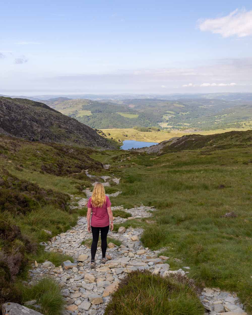
Lots of the beginning of the ridge feels flat, before you begin noticeably descending for around 550m.

You then hit a good path through grass for 350m before the hard part of the descent begins - or hard if you don’t like loose stones anyway!

The steep descent
The next part of the walk was one I definitely didn’t enjoy. I really don’t like steep descents on loose soil or stones, especially when it’s steep. However, I did see someone almost run down, so it definitely won’t phase everybody.

The trail was basically down a steep gully with loose stones or soil, which if I’m honest was less slippery than I thought it would be - but still unnerving because I kept expecting it to become slippery.
There are breaks though and in fact now I’m looking at my notes the worst bit was only 100m long and then there was another similar short rocky section after a big break on a grassy path - in retrospect, it doesn’t sound that bad, but at the time, I definitely didn’t enjoy it!

Between entering the rubbly section and finishing the steep part of the descent (including good paths inbetween), it was 1.1km.

You’re then greeted by a short boggy section as you veer right towards the stile, at the 9.4km mark. After this you’re back on the original trail you came in on and gently descend back towards the lay-by.
All in all, it’s a beautiful trail with fabulous views and it can be adapted to be more or less challenging depending on your preference.

Parking for Moel Siabod
We parked at the lay-by you can find at these coordinates: 53.0960889, -3.8902431.
Parking is free and your time is not limited. However, there isn’t that much space, so on busy weekends and in school holidays you probably need to get here early or later in the day.
The lay-by is 4.5 miles (10 minutes) from Betws-y-Coed and 23 miles (40 minutes) from Caernarfon.
This post may contain affiliate links, meaning at no additional cost to you, that we will earn a small commission if you click through and decide to make a purchase. This helps towards the costs of running our website. Thanks for your support.


