

Utah has some of the most spectacular trails we’ve ever hiked - and that means this list is not just some of the best hikes in Utah but some of the best hikes in the world. We fell in love with Utah on our first visit and as soon as we left we were already plotting our return - which happened six months later despite the fact we don’t live in the States!
It’s not just the scenery, which is famously stunning, but also because of the adventurous nature of a lot of the hikes. Utah’s hikes are truly ones for the bucket list and we can’t wait until we make it back to add even more favourites to this list.
-
1: Kanarra Falls
2: Angels Landing - Zion
3: The Narrows - Zion
4: Chesler Park Loop - Canyonlands
5: Peek-a-boo Gulch - Escalante
6: Spooky Gulch - Escalante
7: Corona Arch - Moab
8: Chimney Rock - Capitol Reef
9: Fairyland Loop - Bryce
10: Navajo & Peek-a-boo Loop - Bryce
11: The Fiery Furnace - Arches
12: Delicate Arch - Arches
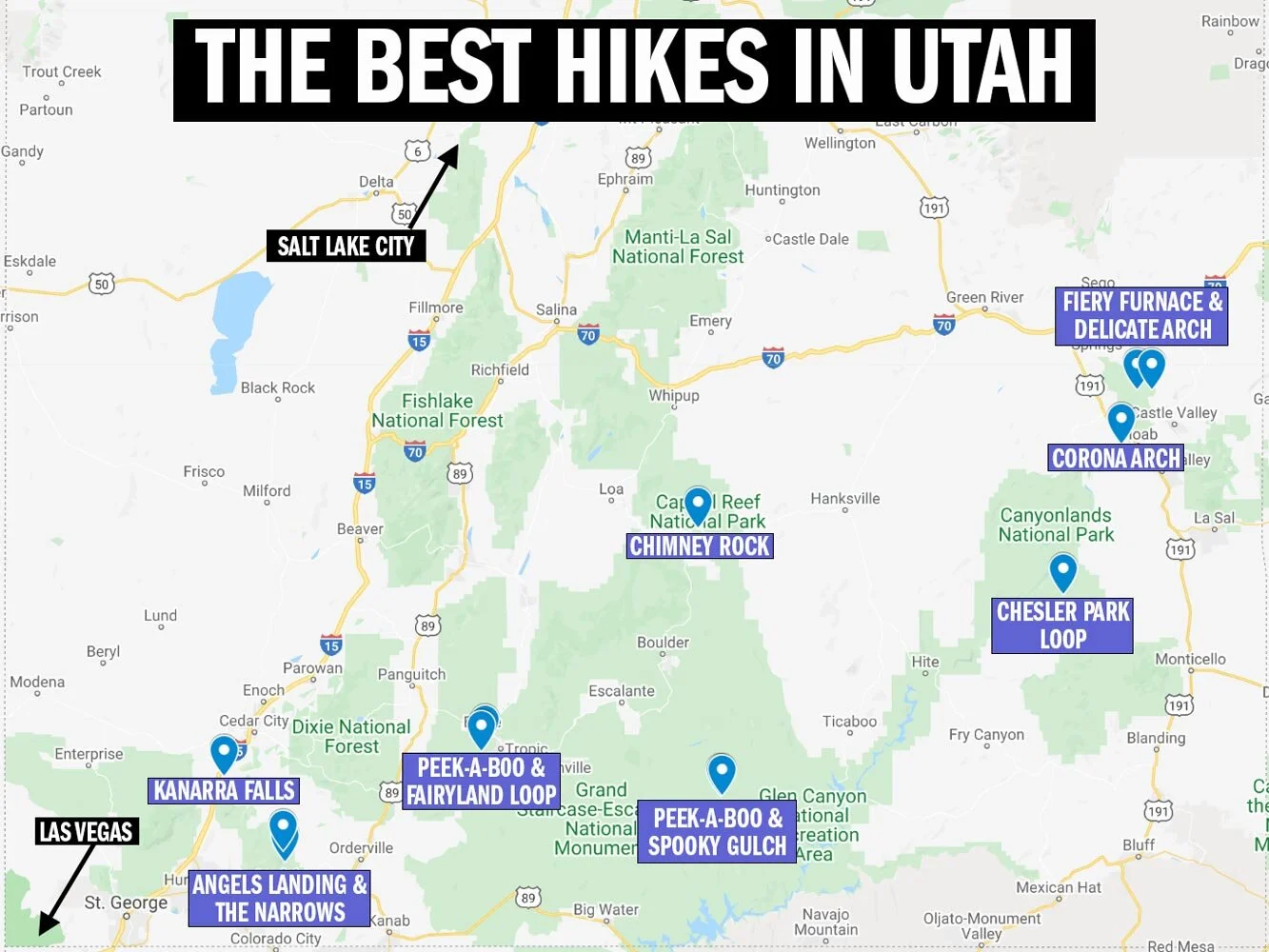
Our favourite hikes in Utah
The map below shows the locations of our favourite hikes in Utah. You can see them all on Google Maps by clicking on this link.
1. Kanarra Falls - Kanarraville
Distance: 4.5 miles (7.29km)
Elevation: 767 feet (234 metres)
Difficulty: Moderate
Kanarra Falls used to be a local’s secret, but it’s firmly out now and you’ll need to secure a permit for this hike - it’s easy though and we outline it all in this post. If you’re looking for a couple of epic slot canyons which are easily accessible on a relatively short hike this one is for you! It’s an unassuming start to the hike on a wide and not particularly inspiring trail but it isn’t long before you hit the creek and the adventure begins.

Beautiful fall colours at Kanarraville
If you’ve never hiked in a wet canyon before this is a good place to start because it isn’t deep and powerful like the Narrows but is still utterly spectacular and exciting. After a short time in the river you’ll come to the start of the first slot canyon and this is where it gets dramatic. The tall walls begin to narrow and loom over you, casting out all light.
To say it feels awe inspiring feels like an understatement. Once you’ve made your way through the canyon you come to a rickety old ladder and in true Utah style this is your route to canyon number two - watch out for the top three rungs which wobble!

Slot canyon one
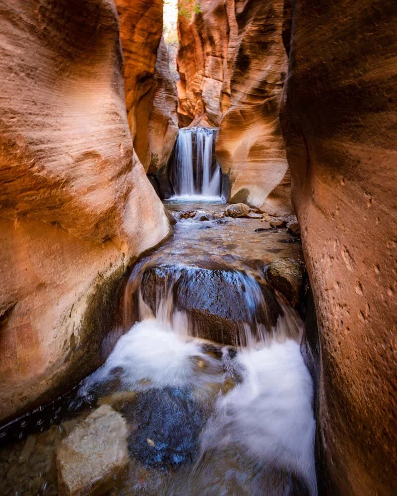
Slot canyon two
Canyon two is different but just as impressive as the first one with a dramatic waterfall at the end. Kanarra Falls, a wild adventure which can be completed in just a couple of hours!
2. Angels Landing - Zion National Park
Distance: 5.5 miles (8.9km)
Elevation: 1500 ft (456m)
Difficulty: Moderate without crowds, hard with crowds
Type of trail: out and back
No list of Utah’s best hikes is complete without the most famous of them all, Angel’s Landing. When people think of this hike they think only of the final section where you make your way up the spine of the mountain using a series of fixed chains.
However, don’t skip this one if the thought of the chains makes your toes curl because the majority of the route is safe and easy, taking you to a lookout (Scout Lookout) with spectacular views which would have made it onto our favourites list in its own right.

Angels Landing beyond Scout Lookout
The initial walk is a mixture of flat trail and two series of switchbacks, the first of which slopes rather gently whilst the second has 21 very short but steep bends known as ‘Walter’s Wiggles’. Then you’ll be at Scouts where you can assess whether you want to push on to the summit along the chains.
The chains seem to instil either a feeling of great excitement or great dread depending on your head for heights. It is categorically not one for vertigo sufferers but it’s also not as bad as some people - including many Youtube videos - make it out to be. If you avoid the crowds by using our hack, you will get tremendous views from the summit having completed one of the most exhilarating sections of any hike in the US, without putting yourself at unnecessary risk.
Just don’t try it in the snow - here’s what happened when we did!

Ascending the final chains

Looking back on the trail from just below the summit
3. The Narrows - Zion National Park
Distance: 5 – 16 miles one way (the full Top Down 16 mile route requires a permit
Elevation: Predominantly flat
Difficulty: Moderate – difficult depending on how far you go
Type of trail: out and back if you are doing a day hike, one way if you are doing the full top down route
Another of Zion’s most famous hikes and another big adventure. The great thing about the Narrows though, is you can hike only as much as you feel comfortable with and still have an amazing experience. You’ll begin by walking for just over a mile on the flat and easy Riverside Walk before you descend the steps into the Virgin River itself.
From there on in, it’s river walking all the way, it will be a couple of miles before you make it to the most spectacular part of the canyon, Wall Street, where the walls narrow dramatically and you truly see what all the fuss is about.

Orderville Canyon just off Wall Street
It’s not an easy hike as you’ll be walking through the river on slippery stones with potentially strong currents and high water levels (depending on the season). It’s also cold water year round. Having said all of that, it is a spectacular hike which has to be seen to be believed.
Here’s our full guide to day hiking the Narrows.

Wall Street

The water really is that colour!
We might only have two of Zions trails on our list but we’ve actually hiked eight in the park so if you have more time there, here’s our list of Zion’s hikes ranked best to worst.
Read next: Mistakes to avoid in Zion National Park
4. Chesler Park Loop - Canyonlands National Park
Distance: 10.7 miles (17.3km)
Elevation: 1650 ft (504m)
Difficulty: Strenuous
Type of trail: Lollipop loop
If you can only hike one trail in Canyonlands, make it this one. It is truly a hike to remember. Walking along the rocky plateau at the beginning might have you wondering why we raved so much but as soon as you hit Chesler Park you will understand.
The rock formations are mind blowing, we were on a tight time schedule on this hike but decided to let it out the window when we reached this section because no one rushes through Chesler Park. The dramatic scenery extends for as far as the eye can see and the huge orange and yellow hoodoos make for a wonderfully whimsical landscape.

Inside the slot canyon on the Joint Trail
When you think it can’t get any better you reach the Joint Trail and one of our favourite slot canyons in Utah. We traversed the long, thin canyon exploring all the nooks and crannies along the way, and never saw another soul.
You can read more details on this track and others in our Canyonlands hikes guide.

In the slot!

The spectacular Chesler Park
5. Peek-a-boo gulch - Escalante
Distance: 2 miles (3.2km)
Elevation: 700 feet (213 metres)
Difficulty: Moderate but with some scrambling involved
Type of trail: Out and back but can be combined with Spooky to form a loop. The loop is 3.5 miles.
Getting to Peek-a-boo Gulch is an adventure, and even climbing up to the start of the hike isn’t straight-forward! This slot canyon is tucked away in Grand Staircase Escalante National Monument, down a 26 mile dirt road. You then begin the hike down to the foot of the gulch. Entering the slot canyon is a little tricky with several footholds to get you up the steep entrance way!

Inside Peek-a-boo slot canyon
However, once you make it in you’ll discover an epic slot canyon hike with hardly anyone else around. The canyon meanders along, winding round corners, occasionally squeezing in tight and constantly making you think about how best to scramble along.
The trail is short, but can be extended if you take the joining track to Spooky Gulch. If you’re looking for a hiking trail in Utah that’s adventurous and low on crowds, this is the one for you!

6. Spooky Gulch - Escalante
Distance: 3 miles (4.8km)
Elevation: 700 feet (213 metres)
Difficulty: Moderate. Some scrambling involved.
Type of trail: Out and back but can be combined with Peek-a-boo to form a loop. The loop is 3.5 miles.
This incredible slot canyon is not one for claustrophobics. I am not normally too bothered by tight spaces but did find Spooky a little unnerving in certain spots. The good news is if you are worried and walk it as a return hike instead of a loop combined with Peek-a-boo, you can go only as far as you are comfortable with.
The walls at the entrance are fairly wide but it gets a whole lot smaller after that. You will have to turn on your side (watch the walls on bare skin as they can be abrasive) and edge your way through the deep orange walls, it definitely feels like an incredible adventure.
At first it is easy and flat but then you start to have to climb up parts of the canyon. As a novice to all this I found some climbs a challenge (in that sense the loop version of this hike would be easier as you would descend these bits). I needed a bit of a push up from behind on certain sections.

It’s a tight squeeze!
The fact that Spooky is not one way means that if anyone has to pass you it is very difficult. For this reason if I went back I’d go very early in the morning so I wouldn’t have to worry about that. People who had brought backpacks were particularly challenging to pass and often you had to walk back quite some distance to physically manage!
There’s no doubt that this is one of the most adventurous slot canyons a novice can do and I loved the experience despite it’s challenges. We’ve got more details on Spooky and others in our post on hiking in Grand Staircase Escalante.

Spooky’s entrance is a lot wider than it gets further along
7. Corona Arch - Moab
Distance: 2.5 miles (4.05km)
Elevation: 456ft (139m)
Difficulty: Moderate
Type of trail: Out and back
Surprisingly one of our favourite arches in Utah isn’t actually in Arches National Park and lies just a 20 minute drive from Moab town centre. It’s a short trail but this is Utah, and even short is usually exciting. You’ll traverse slick rock before reaching a short climb which is aided by a ladder in one place and a cable in another.

Spot the tiny humans!
It’s not difficult and it adds a bit of interest to the trail - assuming the amazing deep red desert landscape isn’t enough! In just over a mile you’ll reach the huge arch which is one of the largest we saw in the area and a truly beautiful spot. We visited for sunset and the light was lovely, although sunrise would be better if you don’t mind an early start.
You can read about our other favourite hikes around Moab here.

Sunset at Corona Arch
8. Chimney Rock - Capitol Reef National Park
Distance - 4 miles (6.35km)
Elevation - 180 metres
Difficulty - Moderate
Type of walk - Lollipop Loop
This walk was recommended to us by a ranger and I’m glad it was because I wouldn’t have picked it out myself as I didn’t think it strayed far enough from the road. It actually turned out to have some of our favourite views in the park and we didn’t see anyone else on this trail!

Magnificent views on the Chimney Rock Trail
The road actually turned out to look spectacular from above so we were glad we got some good views back to it. The hike starts off heading uphill on a fairly steep track but it isn’t long before it flattens out. The scenery is completely breathtaking throughout, and the rock formation for which the trail is named is actually just a small part of the overall beauty of the hike.
We loved this track and the dramatic red rock landscape backed by snow-capped mountains was a real treat. If you love history we would also recommend checking out the Pioneers Register hike (also known as the Capitol Gorge Trail) where you can see graffiti from the 1800’s! We’ve got the details on both hikes as well as other things to do in the park in this post.

The famous Chimney Rock
9. Fairyland Loop - Bryce National Park
Distance: 8 miles (13.4 km)
Elevation: 1580 ft (482m)
Difficulty: Moderate
Type of trail: Loop
We drove for 15 hours to reach Bryce for the second time as the first time we visited every good hiking trail was closed due to snow. Around one mile into this hike I declared for this alone the drive had been worth it.
That’s just how amazing the Fairlyland Loop is. You will walk for eight miles through some of the most magnificent and unusual scenery on earth.

Views you have to see to believe!
The trail has ups and downs but it’s not too difficult (unless you are hiking on a really hot day) and the hike is interesting and diverse throughout. You’ll walk into the canyon with the famous hoodoos towering over you, as well as along the canyon rim where you can get some incredibly dramatic views from above.
The incredible rock formations and sheer wonderland nature of it all made every single step on this eight mile loop an absolute delight.

Hoodoos galore!

We got most of the trail to ourselves!
How this is one of the quietest trails in Bryce I’ll never know - maybe it’s the length or maybe those in the know are keeping the lid firmly on it to make sure it remains a blissfully peaceful walk through some of the most dramatic scenery in Utah.
We’ve got all the details in our guide dedicated to the Fairyland Loop.
10. Navajo Loop & Peek-a-boo Loop - Bryce National Park
Distance: 5 miles (8.7km)
Elevation: 1,400 feet (437m)
Difficulty: Moderate
Type of trail: Loop
It’s an incredibly tough call when we loved the Fairyland Loop so much but if we had to call it, the Navajo and Peek-a-boo Loop just pips it to the top spot on our favourite hikes in Bryce list. The beginning of this trail is along the famous Wall Street where you descend into the canyon on a series of sloping switchbacks.

There are several amazing sets of switchbacks on this trail
This is the busiest stretch of track we experienced in Bryce and it was a bit of a shock to see huge crowds and selfie sticks galore. But don’t fear because they all but disappear as soon as you come to the bottom of Wall Street and what nobody seemed to realise is the best is yet to come!
You’ll walk through a short but dramatic slot canyon before coming to the junction with the Peek-a-boo track. Whatever you do, don’t miss this addition. I can’t think of a single word that could adequately describe what you will see but I’ll go with jaw dropping.

Is this real life?!

The colours get even more dramatic close to sunset
There are hoodoos galore as well as secret little doorways, another mini Wall Street - with zero crowds - and then another amazing set of steep zig zags with huge towering red cliffs above you as you make your way back to the canyon rim.
We’ve given you all the details and more photos in this post.
11. The Fiery Furnace - Arches National Park
Distance: 2.16 miles (3.48km)
Elevation: 351ft (107m)
Difficulty: Moderate
Type of trail: Loop
It’s almost impossible to choose a favourite hike in Arches but if you were to twist my arm I’d have to say it was this one. We’d never done a walk like the Fiery Furnace and sadly we’ve found nothing like it since. You might look at the stats and wonder how such a short walk could be so incredible but we can assure you that it is.

Navigating our way along the Fiery Furnace walls
Imagine a maze with an occasional arrow pointing the way. That maze is made up of towering red hoodoos and slick rock which you have to scramble up and down, squeeze through, and sometimes even move like a crab along, and you get some idea of the amazing hike that is the Fiery Furnace.
You must have a permit for the hike (we outline how to get it as well as heaps more information on the hike in this post) and they encourage you to go with a guide on your first visit - we didn’t and we loved it! It’s a sensitive area so you need to follow all the rules as you make your way through, which took us around two hours but can take a lot longer if you get lost. I’m not sure I’ve ever had more fun on a two hour hike in my life so hopefully that puts the Fiery Furnace firmly on your Utah hikes bucket list!

Fun and games in the Fiery Furnace
12. Delicate Arch - Arches National Park
Distance: 3 miles (4.8km)
Elevation: 328ft (100m)
Difficulty: Moderate
Type of trail: Out and back
The most famous arch of them all, found on Utah number plates and the quarter dollar coin, won’t disappoint. You might notice that the parks service marks this hike as difficult and says there is a narrow section before you reach the arch but we thought it was much easier than many of the other trails they mark as difficult so don’t let this put you off.

Delicate Arch at sunset
Whilst the hike does begin on a flat trail it isn’t long before you start heading uphill, first on a standard track and then on slick rock - perfectly grippy in dry weather. It is fairly steep but it doesn’t take long until it starts to flatten out a bit and then you are really close to the aforementioned narrow ledge. You can see from our photo that it really isn’t very narrow at all and would only be worrying if you suffer from severe vertigo.
Once you’ve walked the ledge you’ll see the stunning Delicate Arch ahead of you in the distance. You can sit and take it in from here or you can skirt the side of the sloping rock (not difficult) to get right up to the arch. It’s a magnificent spot and definitely one not to be missed. It’s easy to see why it became an Instagram sensation.
If you are looking to get good photographs of the arch sunrise is the best time, followed by sunset.

The spectacular Delicate Arch

The aforementioned narrow ledge
Packing suggestions for hiking in Utah
Having the right gear can make a huge difference, whether it’s hiking during the hot summers, or the potential snow in the winter. Here’s what we pack and have relied upon for years:
Day Pack: Osprey Talon 22 (we’ve owned this for years). Check on Amazon, REI or direct with Osprey
Hiking Boots: Merrell Moab (for men and women). We’ve both used these for over three years and they just keep going. Check them out on REI or Amazon
Trekking poles: We’ve used Black Diamond for years as they are light, solid and durable. Check out REI or Amazon
Reusable water bottle: To avoid single-use plastic. Check then out on REI or Amazon
For winter
This post may contain affiliate links, meaning at no additional cost to you, that we will earn a small commission if you click through and decide to make a purchase. This helps towards the costs of running our website. :-)
Like it? Pin it!


Follow us on social media
Are you planning a trip to Utah? Is there a hike in Utah you love that didn’t make the list? Let us know in the comments below!


