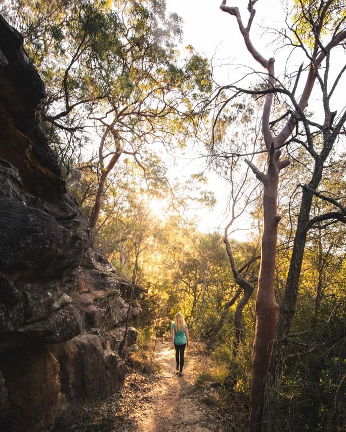
We love Ku-ring-gai National Park. There are some fantastic and diverse walks here that seem to fly under the radar. While many of the stunning walks in Royal NatIonal Park are well known, when we post pictures from Ku-ring-gai they are usually met with questions about where on earth they are taken.
We’ve walked most of the trails in the park and put together this list of our favourites, with something for everyone, from easy strolls to more challenging hikes. From the bush to the coast we have you covered. This is a park that is also well known for Aboriginal engravings which are easily accessible and well worth checking out.
Here are the best walks in Ku-ring-gai National Park that you really need to add to your list!
The Best Ku-ring-gai National Park Walks
Planning your walk
Ku-ring-gai Chase National Park is made up of three different areas: West Head, Bobbin Head and the trails around the eastern side of Mount Ku-ring-gai; Cowan, Berowra and Brooklyn (we’ll call it Cowan Creek).
The thing to remember is that these three areas are surprisingly far from each other, and West Head and Bobbin Head have only one road in and out. Whilst West Head and Bobbin Head may not look far apart, it actually takes about 45 minutes to drive between the two.
For this reason, we recommend concentrating on a single area each time you visit. The Cowan Creek area is also the only area of the three which doesn’t have a national parks entry fee.
-
These are the 13 most beautiful Ku-ring-gai Walks
1. America Bay - West Head (Easy)
2. Towlers Bay Circuit - West Head (Moderate)
3. West Head Army Track - West Head (Moderate)
4. Resolute Loop - West Head (Moderate)
5. Koolewong Track - West Head (Easy)
6. Basin & Mackerel Circuit - West Head (Moderate)
7. Lovett’s Pool - West Head (Easy)
8. Topham Track - West Head (Easy)
9: Flint & Steel Beach - West Head (Easy)
10: Gibberagong Track - Bobbin Head (Moderate)
11: Sphinx Memorial to Bobbin Head (Moderate)
12. Berowra to Mt Ku-Ring-Gai - Cowan Creek (Moderate)
13: Jerusalem Bay Track - Cowan Creek (Moderate - hard)
The best walks in the West Head Area
The first nine trails are in West Head, a bush fringed headland opposite Palm Beach on the Northern Beaches. It’s the most famous part of Ku-ring-gai and is mostly known for bush tracks that start up high and then head down to the coast. Of course this means you then have to hike back up!
This area has a trail for everyone: from short, but picturesque views at America Bay, military history at the West Head Army Track and some of Sydney’s best beaches on the Resolute Beach Track. There are also a few hidden gems.

Getting to West Head
The only public transport to West Head are the ferries that run from Palm Beach that run to Mackerel Beach, Currawong Beach and Soldiers Point.
Otherwise the journey by car to West Head takes just under one hour from the city. The only way into West Head is passing a national parks booth, where you will have to pay $12 per day if you don’t have an annual pass.
Be aware that West Head also has a gate that gets locked in the evening, times vary with the seasons, so you will want to be out on time to avoid paying the “re-opening fine” of $50.
1. America Bay Track - the best for sunset
Difficulty: Easy
Distance: 2km return
Elevation: 73m
Type of Trail: Return
Accessible by public transport: No
The America Bay Track is an easy walk but with a big pay off. You’ll have the chance to see Aboriginal engravings which are in great condition, some pretty bushland and then finish the walk at a waterfall with amazing views over the bay.
Keep an eye out for Goannas in the bushy section of the track, it’s known as a good place to see them.

The final lookout over America Bay is the perfect spot to come for a picnic or to watch the sunset. It’s a jaw dropping view and the kind of spot you could come and sit for hours - and we do!
The path is quite uneven so whilst it’s fairly easy you will want proper shoes. You also need to make sure you get back to your car before the gate is locked, you have time to watch sunset, but don’t linger and check the lock gate timings!


You can read our full America Bay trail guide here.
2. Towlers Bay Circuit - the best for a secret viewpoint
Difficulty: Moderate
Distance: 6.9km
Elevation: 270m
Type of Trail: Circuit
Accessible by public transport: No
This walk is amazing and yet so few people know about it. It’s highly likely you’ll get the whole thing to yourself.
As well as a truly breathtaking secret lookout, you’ll walk through the jungle and get the chance to have a picnic in a cave! It’s a slightly overgrown trail in parts but that does all add to the adventure!

This walk really feels like you’re getting away from it all and the jungle section is like stepping into the wilds. It’s not a hard walk but you do have to be prepared for some overgrown parts, and if you’re walking after rain, the odd leech or two - I found out the hard way!

Even though I got ‘leeched’ it’s still one of my favourite walks in the whole park.
You can read the full guide here, including how to find the trailhead, as it isn’t marked.
3. West Head Army Track - the best for adventure
Difficulty: Moderate
Distance: 1.36km
Elevation: 105 m
Type of Trail: Return
Accessible by public transport: No
For such a short trail this one really packs a punch.
It’s one of the newer tracks in the park having only opened in mid 2016. It’s basically a straight up, straight down scenario, some of which is on what ParksNSW describe as ladders.
We wouldn’t really call them ladders, more like steep staircases but they were still pretty fun!

I loved the fact that you start on bush track but by the time you hit the bottom it feels like you're in the jungle! There’s the chance to explore some old bunkers and gun turrets left over from the Second World War which was pretty cool, although unfortunately there aren’t any information boards to give you a deeper understanding. The views over the Hawkesbury River are also absolutely stunning.


This is a short trail, so whilst it’s steep, it will be achievable for most people. Whilst the track sign says it’s hard, we don’t really agree.
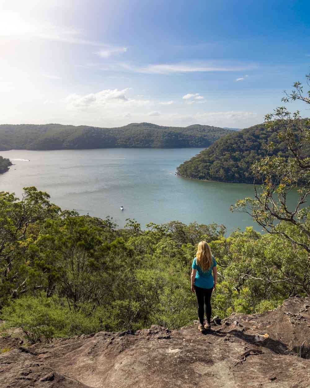
4. Resolute Loop - the best for stunning beaches
Difficulty: Moderate
Distance: 5.2km or 6.6km for all three beaches
Elevation: 295m if visiting all beaches
Type of Trail: Circuit
Accessible by public transport: No
The Resolute Loop is a fantastic walk and takes you to some of the very best beaches in the whole of Sydney. Along the way you also get to visit West Head Lookout for one of Ku-ring-gai’s most popular views and Red Hands Cave where you can see ancient Aboriginal rock art.
It’s in our top three walks in Ku-ring-gai.
The track is largely through the bush but takes you to visit three outstanding beaches - West Head, Resolute and Great Mackerel.

West Head and Resolute have that wild and deserted island feel to them and are great for swimming, with pretty calm water. They are nicely secluded and both made it into our favourite secret beaches in Sydney list.
Mackerel Beach is much larger and also absolutely stunning. It is often very quiet but it does have a ferry service from Palm Beach so it can be busier on sunny weekends.


The track is not difficult but each time you visit a beach you have to descend fairly steeply and then obviously climb back up after! Every single stair is worth it, trust us.
Here’s our full trail guide with exactly what to expect.
5. Koolewong Track - the best for an easy win
Difficulty: Easy
Distance: 1km
Elevation: 48m
Type of Trail: Circuit
Accessible by public transport: No
This is a very easy short but sweet trail that leads to a fabulous view over Lion Island, Patonga and the Hawkesbury River.
The best thing is that you will likely have it all to yourself as most people head a little further along to the West Head Lookout. It’s such a peaceful and serene spot, I find it very difficult to leave!

The walk itself has a few stairs but it’s generally a very leisurely and relaxing stroll through the eucalyptus trees with lots of birds flitting across the path. It’s particularly beautiful in the soft light of the late afternoon.
6. The Basin and Mackerel Circuit - the best for spotting wallabies
Difficulty: Moderate
Distance: 7km
Elevation: 189m
Type of Trail: Circuit
Accessible by public transport: No
The Basin and Mackerel Circuit really does have it all: well preserved Aboriginal engravings, a fabulous viewpoint, gorgeous bush land, several calm water beaches, and the most wild wallabies we've seen anywhere in the Sydney area. On top of all that, this walk is a lot of fun and easily one of our favourite trails in Sydney.
It might begin on underwhelming fire trail, but it isn't long before you reach a really pretty bush track and then head down onto the first of many beaches.

To make it a circuit you'll want to be walking at low tide or close to it. We hiked two hours before low tide and were in thigh deep water, but to be honest even that was a lot of fun!
Once you make it to the Basin campground, you'll be surrounded by dozens (literally!) of wild wallabies, happily grazing on the lawn. They aren't overly shy and it's a real privilege to sit and observe them.


Whilst much of the trail is flat you do have one fairly hefty climb up from the campground, which lasts for around a kilometre.
You can read all the details - including which paths to take as the circuit is not signposted in this post.
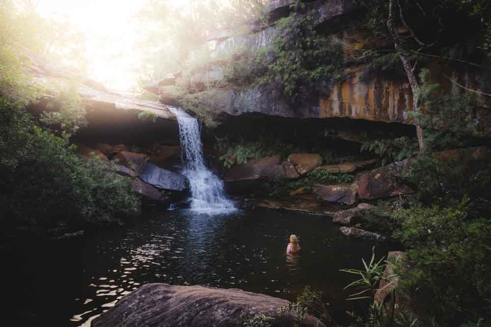
7. Lovetts Pools - the best for wild swimming
Difficulty: Easy
Distance: 3.2km return (including the side trail)
Elevation: 60m
Type of Trail: Return
Accessible by public transport: No
The walk to Lovetts Pools is not a beautiful one in and of itself, but along one easy trail you'll visit some well preserved Aboriginal engravings, a fabulous lookout and of course the gorgeous swimming hole.
It's not a signposted walk, so it seems to see few visitors and you can often get the waterhole all to yourself, even on a weekend. It's the perfect place to cool off on a hot day, or just sit and relax with a picnic. If there has been recent rain, you'll also find a small waterfall and the sound of the running water adds a peaceful atmosphere to this already serene spot.

The trail is relatively flat and the path is in good condition when dry, it does get waterlogged after rain, but even so it's not difficult.
You can read our full trail guide here.
8. Topham Track - the best for a very cool cave
Difficulty: Easy
Distance: 4km return
Elevation: 120m
Type of Trail: Return
Accessible by public transport: No
If you walked the Topham Track without doing the short diversion to the secret cave, then you'd probably wonder why on earth we included it on our best walks in Ku-ring-gai list. The bulk of the track is along a fire trail, which though pleasant enough, is clearly nothing to write home about.

However, venture just a few hundred metres off the beaten track and you'll find a wonderful viewpoint in one direction and a really cool cave in the other. The cave is one of our favourite spots in the park, with gorgeous swirly sandstone walls and a sensational view over Refuge Bay and Cowan Creek.
The trail is easy enough with very little in the way of climbing to do and the short section that is off track (to reach the cave and viewpoint) is a little rougher, but still straightforward.

You can read all the finer details in our Topham Track guide.
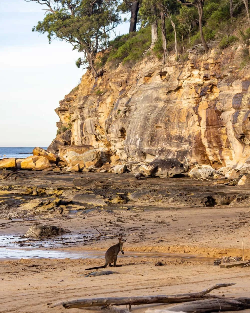
9. Flint and Steel Track - the best for swimming in calm water
Difficulty: Easy
Distance: 2.6km return
Elevation: 130m
Type of Trail: Return
Accessible by public transport: No
We thought this trail would be all about the beach, but in fact it's quite lovely in and of itself. You'll walk between masses of cabbage palms and other dense foliage which gives great jungle vibes before following a narrow path with glorious views out to the water.
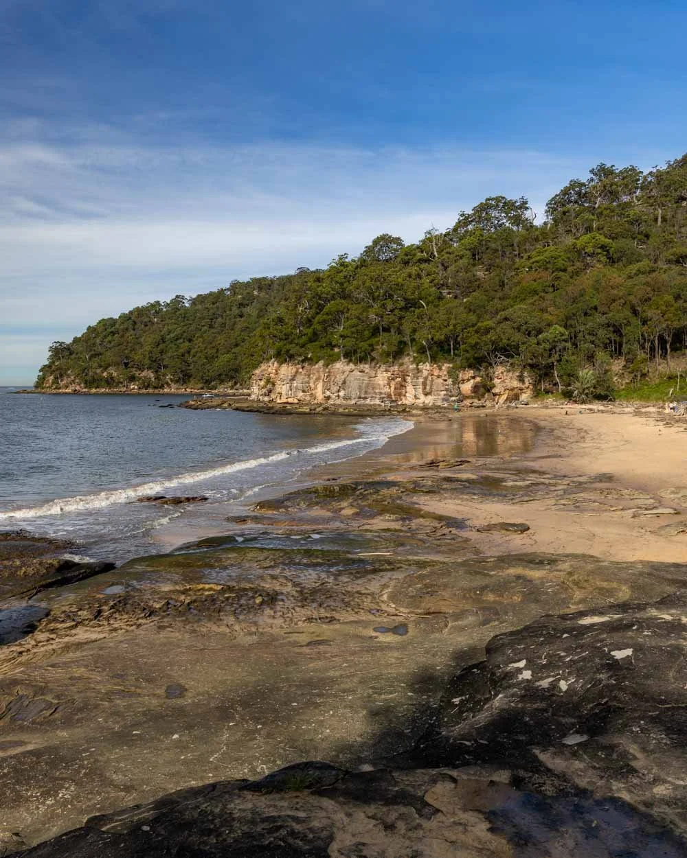
You'll soon arrive at Flint and Steel Beach which is a lovely secluded spot. It's great for swimming with very calm water, although you don't want to visit after heavy rains/storms when the beach can become littered with driftwood.

However, the thing we love the most about this beach is the wallabies! They aren't shy and will happily skip along the sand in front of you (if they're not on the beach, look at the bushland behind the sand and you're almost guaranteed to see one).

The walk itself is on a well-maintained track and is mainly downhill on the way and a steepish climb back up. A couple of sections are rocky, but it's generally an easy trail.
The best walking trails in the Bobbin Head Area
Bobbin Head is a pretty small area, but it has several fantastic walking trails including two of our faves that made it into this list .
These trails are both bush walks that head to Cowan Creek, and if you want a true city escape, these are the trails to head for. It feels wild and beautiful.

Getting to Bobbin Head
Bobbin Head is a 40 minute drive from Sydney and the Marina falls within a fee area for the national park. However, you can start both trails outside of the gate if preferred!
These trails are also accessible by public transport. It’s requires effort, but it is possible.
10. Gibberagong Track - the best for an into the wilds feeling
Difficulty: Moderate
Distance: 12.8km or half if you can organise a car shuffle
Elevation: 304m
Type of Trail: One way or return
Accessible by public transport: Yes
It took us years to finally do this track and once we got there we had no idea why we left it so long! It’s a wonderful trail taking you through some truly gorgeous forest, some of which felt just like rainforest.
In fact, there were parts that felt like we’d been transported to Far North Queensland with lots of huge mossy boulders in the emerald creek.

There are lots of gorgeous spots along the way where you can stop for a swim and it’s likely you’ll get it all to yourself!
It’s a fairly rough track with lots of undulations and climbing over rocks and tree roots, but it’s never a scramble.


Towards the Bobbin Head end of the track there are some great views above the creek and even some Aboriginal engravings and axe grinding grooves.
You can read more in our detailed Gibberagong Track guide.
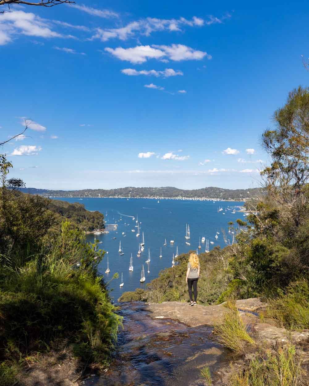
11. Sphinx Memorial to Bobbin Head Loop - the best for peace and tranquility
Difficulty: Moderate
Distance: 10km
Elevation: 267m
Type of Trail: Circuit
Accessible by public transport: Yes but it’s not a great journey!
This is the first trail I walked in Ku-ring-gai and it’s still one of my favourites bush walks in Sydney today. The walk takes you through some truly beautiful bushland, with hundreds of ferns and the birds offer a constant relaxing sound track.
The creek views are also great and there’s a cafe at the marina which is the half way point. Who can resist a mid walk coffee or ice cream?!

It’s also a trail where we have regularly seen wallabies on. It tends to be in the late afternoon, but seeing these animals is just as much of a treat today as it was the first time we ever saw them.
There are a few climbs on the trail, and it is sometimes rocky, but for the most part it’s not too steep. The only sustained climb comes directly after the cafe when you’ve had a chance to fuel up!


Here’s the full low down on the Sphinx Memorial to Bobbin Head Loop.
The best walks in the Cowan Creek Area
The last two trails are ones that hike down to Cowan Creek from small towns on the Pacific Highway. They are known for being some of the steeper tracks in the park, but they reward you with stunning riverside views where you’ll often see more animals than people.

Getting to the Cowan Creek Area
These trails are the best for anyone without a car as they start and end at train stations. They are also one-way walks, so you don’t have to go back on yourself at any point.
They are is a 45 minute to one hour drive from the city. You can park for free at any of the train stations and get the train back to your car. This is our preferred option as the trains can be up to an hour each way - something that isn’t great when you’ve got sweaty on a bushwalk in the summer!
You don’t have to pay the park fee for either of these trails.
12. Berowra to Mount Ku-ring-gai - the best for waterside views
Difficulty: Moderate
Distance: 10km
Elevation: 324m
Type of Trail: One way
Accessible by public transport: Yes
If you can’t get enough of walking along Ku-ring-gai’s beautiful creeks then this is definitely the walk for you. You walk alongside the water for longer than any other trail in the park, over 6km to be more precise!
We couldn’t believe it as we walked along, constantly expecting to turn away from the creek, but it just kept on going! It made for a very relaxing walk, and it is a particularly quiet trail too.

As well as the creek you’ll also walk through some pretty bushland, alive with the calls of the Whipbirds. The trail takes you between two train stations, with almost no walking outside the national park boundary, which is a real treat if you don’t have a car.
There is one steep descent and one steep ascent with some undulating trail along the way but it’s not a difficult walk and it’s much less steep than the Berowra to Cowan, or Cowan to Brooklyn trails.


We’ve got more information in this detailed trail guide.
13. The Jerusalem Bay Track: Cowan to Brooklyn - the best for a good workout
Difficulty: Moderate - hard
Distance: 14.4km
Elevation: 482m
Type of Trail: One way
Accessible by public transport: Yes
This is the hardest and steepest trail on our list, but even if you’re not a regular hiker, don’t be put off because there are lots of places to rest along the way.
It’s another station to station walk and takes you through some fab bushland and down to the absolutely gorgeous Jerusalem Bay, which is a great place to stop for a picnic, and even a dip if you’re so inclined.

It’s followed by a fairly big climb and then several smaller climbs as you make your way to Brooklyn. Some of the track has quite rough terrain, but there are never any parts that are exposed and I wouldn’t say it’s particularly slippery, just quite rubbly.
The only downside to this trail is that half is wonderful and half is not so great, along fire trail. The first half makes up for the less exciting second half in our opinion though!


You can learn more in this detailed guide to Jerusalem Bay Track.
Essential information about Ku-ring-gai National Park walks
Ku-ring-gai National Park entry fee
The vehicle entry fee applies to some of these tracks which is $12 per day. If you are planning on visiting several NSW parks in a year you are likely better off buying the annual pass which covers all parks apart from Kosciusko.
In each individual trail guide we have let you know at the bottom which have fees, this is easier than writing a blanket statement as sometimes the same trail can have a fee or not depending on which end you start at!
The fee is for vehicles only and does not apply to those entering the park on foot or bicycle.
Ku-ring-gai National Park opening times
Some of the walks are in parts of the park that have strict opening times and are enforced by a locked gate. If you get your car stuck and have to have the gate opened it’s a $50 fine. The timings vary slightly by season but broadly it’s sunrise to just after sunset.
All the tracks along the West Head Road are subject to these timings but for the other tracks it can be avoided depending on where you park. Again we’ve covered this on a walk by walk basis in the individual track guides.
Packing suggestions for the Ku-ring-gai
Having the right gear can make a huge difference, especially in Ku-ring-gai. Most of the trails are very exposed and it can rain at any time, so packing correctly can make a big difference.
Here’s what we pack and have relied upon for years:
Sunscreen: Cancer Council Active. With a high SPF, but not the greasy feel of other sunscreens. Makes a big difference when you’re working up a sweat on a sunny day! Check it out on Amazon
Good Rain Jacket: North Face This is an essential item we always pack in our bag! This jacket from North Face is designed to keep you dry but also comfortably warm (many rain jackets will make you feel like you’re in a sauna). Check it out on Amazon
Day Pack: Osprey Talon 22 (we’ve owned this for years). Check on Amazon or direct with Osprey
Hiking Boots: Merrell Moab (for men and women). We’ve both used these for over three years and they just keep going. Check them out on Amazon
Trekking poles: We’ve used Black Diamond for years as they are light, solid and durable. Check them out on Amazon.
Reusable water bottle: To avoid single-use plastic. Check them out on Amazon
This post may contain affiliate links, meaning at no additional cost to you, that we will earn a small commission if you click through and decide to make a purchase. This helps towards the costs of running our website. Thanks for your support.
Like it? Pin it!

Follow us on Social Media
Are you planning a walk in Ku-ring-gai Chase National Park? What’s your favourite trail in the park? Let us know in the comments below!