

The Grampians have some of our favourite hiking trails in the whole of Australia; so good we’ve done many of them twice, despite living pretty far away in Sydney!
There’s something for everyone, from easy strolls to more adventurous trails - which require a bit of scrambling. You’ll be spoilt with gorgeous waterfalls, 360 degree views, Indigenous rock art and some of the most interesting trails in the whole country.
Here are our top tips for the best walks in the Grampians.
The Best Grampians Hikes
These are the best hikes in the Grampians:
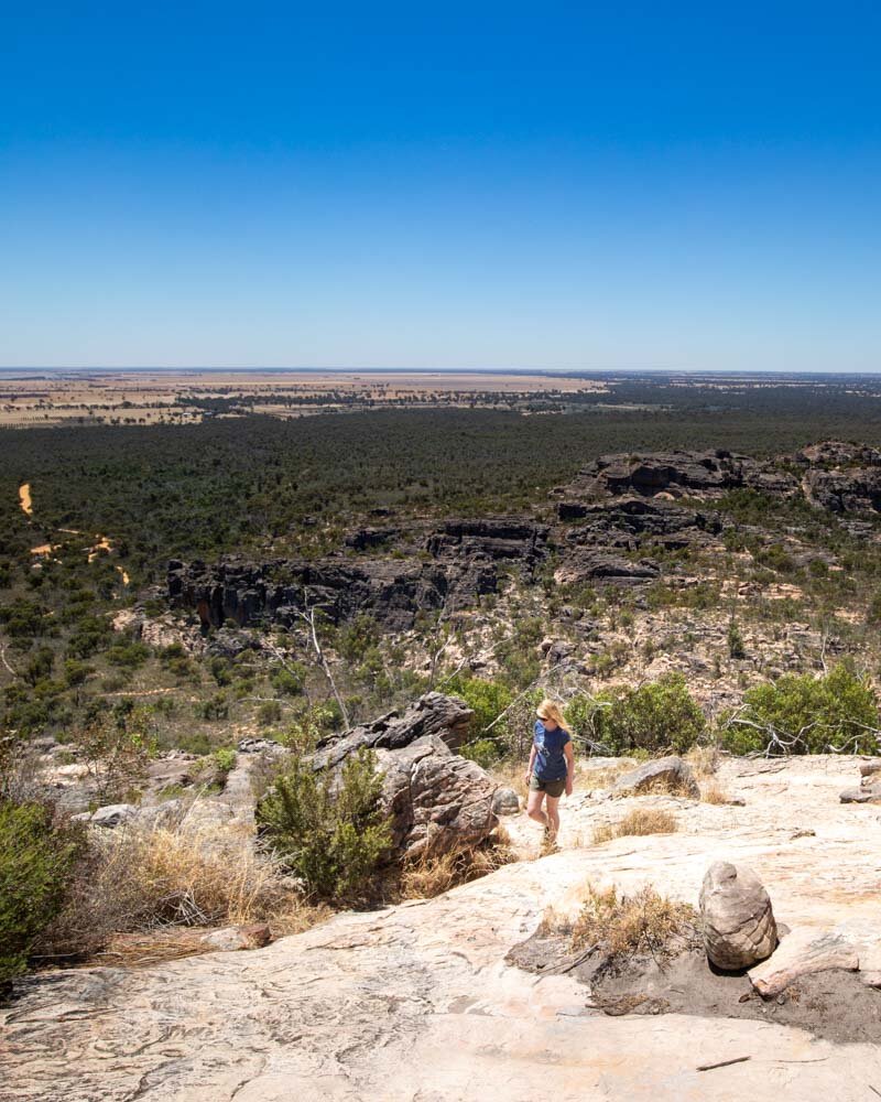
1 - The Pinnacle
Distance: 4.5km (2.8 miles) return
Elevation: 300m (985 ft)
Time taken: 1 hour 30
Start point: Wonderland carpark
The Pinnacle is hands down our favourite hike in The Grampians, and we aren’t the only ones. It’s on most people’s hit list, so we’ve only ever hiked this trail in the late afternoon so we can avoid the crowds! It works a treat, and one time we even had the entire thing to ourselves by starting at 7pm (sunset was at 9pm).
The easiest route to the Pinnacle is from the Sundial carpark, but we’d highly recommend putting in a touch more effort and starting at Wonderland (you can also start at Halls Gap, but that is a much longer route and we haven’t tried it ourselves).

The viewpoint at the end
The Wonderland route begins by heading straight into the Grand Canyon and whilst that name might be pushing it a little bit, it is a very beautiful canyon. For the majority of the trail you will be walking on rock which I loved as it makes a fun change from a well formed track.
There are quite a few stairs to climb, but there are also many flat sections to balance it out and get your breath back. Silent Street is another track highlight where you walk through the middle of a slot canyon aided by stepping stones. It’s unlike any other walk we’ve done in Australia.

The Grand Canyon

Silent street
The lookout at the top is fantastic, with great views of the jagged sandstone mountains and the deep blue reservoir - but to be honest, the track alone would be more than enough, even if there was no view at the end!
Here’s our detailed run down of the Pinnacle hike.
Read next: The ultimate city break - a 2 day Melbourne itinerary
2 - Chatauqua Peak Loop
Distance: 5.3 km (3.3 miles)
Elevation: 210 m
Difficulty: Moderate
The Chatauqua Peak Loop is a fantastic varied hike. You’ll start walking in the bush, where you can keep an eye out for the resident wallabies, before coming out on a ridge with some great views back to Halls Gap.
The start of the track is gentle and from the ridge gets a bit steeper on a series of stairs before you hit the rock.

At this point you will be walking on rock for the last few hundred metres to the peak and there’s a bit of scrambling involved.
The first time I tried it, the scrambling was a bit out of my comfort zone, but on attempt two - after a bit more rough hiking practice - it was my favourite part of the trail.
If you don’t like scrambling, you don’t have to do the final section to the peak, and it will still be a good walk.


You can read our detailed trail guide here.
We recommend taking the loop trail back for variety, as this takes you through gorgeous forest and the botanic garden.
Read next: One of the best hikes in the Mornington Peninsula - The Bushrangers Bay Walk
3 - Hollow Mountain and Gulgurn Manja Rock Art site
Distance: 3.2km (2 miles) return
Elevation: 227m
Difficulty: Moderate
This is a fantastic walk in a quieter part of the Grampians and is a 40 minutes drive from Halls Gap. This hike begins innocently enough on some gentle stairs before you hit a rocky trail which you follow to the peak.
There are a couple of scrambly sections which require the use of hands as well as feet - or they did for me anyway!
You do have to watch your footing, as some of the rock even on the flat or gently sloped sections is a bit jagged and could be a trip hazard.
Don’t let that put you off though, because the walk is a lot of fun and the views are great. There’s also a couple of caves to explore.


On the way back take the 750m signposted trail to your right to the Gulgurn Manja Rock Art site which is well worth seeing.
The cave paintings are pretty well preserved and you can very clearly make our the hand prints and emu tracks. The combination of these two trails makes for a fantastic half day hike.
Here’s our detailed trail guide.
4 - The Balconies
Distance: 2km (1.2 miles) return
Elevation: 30m
Difficulty: Easy
I’m not sure anyone comes to the Grampians without visiting the Balconies.
It is easily one of our favourite views in the whole of the area and the easy flat walking trail takes you to the famous Jaws of the Grampians rock formation.

The best time to visit is either sunrise or sunset for a really special experience. There is a railed lookout and the two access points to the Jaws are now fenced off (they weren’t on our first visit).
In all honesty though, the fence looks a bit half hearted and it doesn’t really deter anyone from walking out on to the Jaws for that iconic photo.

Before or after visiting the Balconies, take a look at Reed’s Lookout which is right by the car park and also offers fabulous views.
Read next: 10 incredible things to do in the Grampians
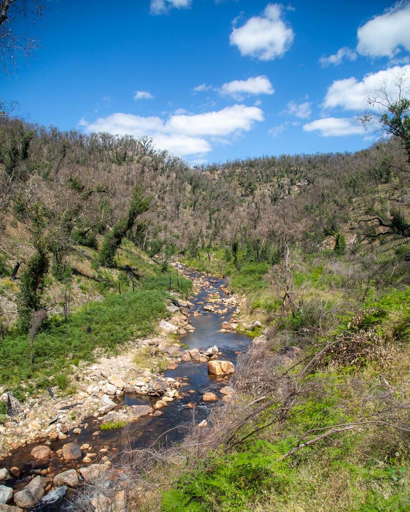
5 - MacKenzie Falls via Zumsteins
Distance: 7km return to the base of the falls (4.3 miles)
Elevation: 124 m
Difficulty: Easy
Lots of people take the shortest route possible to visit the falls from the MacKenzie Falls car park, but we’d recommend starting your walk at Zumsteins. This peaceful riverside stroll was one of the quietest we did in the Grampians, and it’s nice and easy which we appreciated on a hot summer’s day.

MacKenzie Falls
Around half way along the track you’ll reach Fish Falls, which is another pretty spot and a good place to stop and take in the scenery. We hiked this trail a few years ago and you could see a lot of fire damage - lots of burnt trees - but we’ve heard the area is regenerating nicely, so it should be even more beautiful than when we visited.
Continuing through the gorge, it isn’t long before you come to the base of the beautiful Mackenzie Falls, which is one of our favourite falls in Victoria.
You can choose to continue the walk by heading up the steep staircase beside the falls, which is what we did.

You’ll get a view of the falls from above at Bluff Lookout and the chance to see a bit more of the beautiful Aussie bush, including lots of Kangaroo Tails which are some of our favourite native flora.
6 - Mount Rosea
Distance: 9.5 km return (6 miles)
Elevation: 490m
Difficulty: Moderate - hard
Mount Rosea is the meatiest hike on this list and a great option if you’re looking for a longer walk. We hiked this trail on a reeeally hot day and it’s pretty exposed, so it’s a good one to start early if you are hiking in summer.
It’s a stunning walk though, and it seemed that very few people do it - although this could always be because of how hot it was!
You begin the hike in the bush before coming out on a rocky trail, which is in keeping with most of the tracks in the Grampians. You’ll be following arrows - which aren’t always immediately obvious - so keep an eye out. The terrain involves some rock hopping and scrambling, but once you leave the bush the views are great.
There are a couple of bits where you have to squeeze between the rocks, which added to the thrill of the track. I wish there more trails like this near Sydney!

The views get better and better the higher you climb and there are some great rocks which jut out from the track. It made for a good spot to lie down and take a rest from walking in the heat.
At just over 3km in you’ll reach a little bridge over a chasm, at which point you’ll know you’ve nearly made it to the summit. The trail takes you in-between lots of shrubs before you see the railed lookout in the distance. The views from the summit are terrific and there are markers showing you which mountains you are looking at.


You can then make the trail a loop, which is what we would normally do, but we heard that the trail was not as nice as the route we had already taken and involved a bit of road walking, so we chose to return the way we came.
The route is pretty fantastic, so walking the same way back in this instance was a pleasure.
7 - Mount William
Distance: 3.6 km return (2.2 miles)
Elevation: 236m
Difficulty: Moderate
Mount William is the highest point in the Grampians and was our chosen sunset spot for the evening. Unfortunately when we arrived the gate was closed due to a bushfire in the area, so we weren’t able to complete it. We spoke to someone who has done the trail though, so we can outline the basics for you.
The walk is on a steep paved road for the entire way, so it’s definitely not going to be the most exciting in the Grampians in that sense, but the views from the top make the slog worthwhile. The first 600m are said to be the steepest - and do put a lot of people off - but past the bench the gradient gets shallower, so keep going!
Once at the top there are a number of transmission towers but you can take a little trail off to the side which has unobstructed views.
Packing suggestions for the Grampians
Having the right gear can make a huge difference, especially in the Grampians. Some of the trails can be slippery (so you will want good grip) and it can rain at any time, so packing correctly can make a big difference.
Here’s what we pack and have relied upon for years:
Sunscreen: Cancer Council Active. With a high SPF, but not the greasy feel of other sunscreens. Makes a big difference when you’re working up a sweat on a sunny day! Check it out on Amazon
Good Rain Jacket: North Face This is an essential item we always pack in our bag! This jacket from North Face is designed to keep you dry but also comfortably warm (many rain jackets will make you feel like you’re in a sauna). Check it out on Amazon
Day Pack: Osprey Talon 22 (we’ve owned this for years). Check on Amazon or direct with Osprey
Hiking Boots: Merrell Moab (for men and women). We’ve both used these for over three years and they just keep going. Check them out on Amazon
Trekking poles: We’ve used Black Diamond for years as they are light, solid and durable. Check them out on Amazon.
Reusable water bottle: To avoid single-use plastic. Check them out on Amazon
This post may contain affiliate links, meaning at no additional cost to you, that we will earn a small commission if you click through and decide to make a purchase. This helps towards the costs of running our website. :-)
Like it? Pin it!

Follow us on Social Media
What’s your favourite hike in Australia? Have you hiked in the Grampians and have a trail to recommend? Let us know in the comments below!


