Bijagual Falls (or Manantial de Agua Viva - we’ve seen it called both names) is said to be the tallest waterfall in Costa Rica. But then we’ve seen that said about several other waterfalls too! However, none of it matters because if you decide to hike to the bottom of Bijagual Falls, you won’t be disappointed. It’s one of the wilder waterfall hikes in Costa Rica and takes you through a pristine patch of jungle. The screeching calls of the Scarlet macaws will be your constant companion.
In fact, the macaws may be your own companions as we saw eight macaws and just two humans - and this was the middle of the day in peak season. I can imagine you’d be unlikely to see another soul if you’re hiking a little earlier in the day, or outside the height of peak season.
However, when I said the hike was wild, it’s definitely not like the maintained tracks you’ll find to many Costa Rican waterfalls, this one requires a bit more care - more on that later.
Here’s everything you need to know about hiking to the bottom of Bijagual Falls (Manantial de Agua Viva).

Bijagual Falls - the two entrances
Before we get started on the trail notes, it’s worth noting there are two entrances to access Bijagual Falls. One goes to the middle of the falls and one to the bottom.
The routes are both on private property and have entry fees, though no guide is required. The route to the middle falls is more popular and likely to be better maintained, but we don’t know for sure as we didn’t try this option.
We were really keen to get to the very bottom of the falls, so the lower entrance (details below) was the one for us.

The walk to Bijagual Falls (Manantial de Agua Viva)
Distance: 5.6km return
Elevation gain: 320m
Difficulty: Moderate, but a rough trail
We want to be completely up front straight away and say that this hiking trail is not particularly well maintained. The path is pretty steep going down and there’s a decent amount of loose soil, which can be slippery if you’re not surefooted (like me!). There are roped handrails in place at points, but not everywhere you might want them to be.
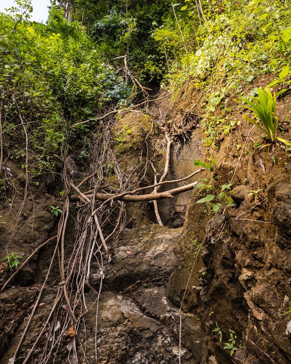
The track also passes evidence of many landslides. These have been cleaned up, but it would make me hesitant to walk this track in the rainy season. We did hike after a fair amount of rain, but nothing like the rainy season would be.
To get to the very bottom of the falls, you need to use two small ladders and take on some boulder hopping - but the final ladder and boulder hopping section is optional as it doesn’t offer the best view. The best view is a couple of hundred metres before.
The climb back up is tiring in the heat, but there are a couple of points you can stop for a breather where you’ll find a bench, and the forest is dense which provides lots of shade.

Starting the trail
From the wooden hut where you pay the entry fee, you can take a photo of the map and grab a stick before you begin descending into the rainforest. After 20m you’ll see a flush toilet with toilet paper, which I definitely didn’t expect in this rustic set up!

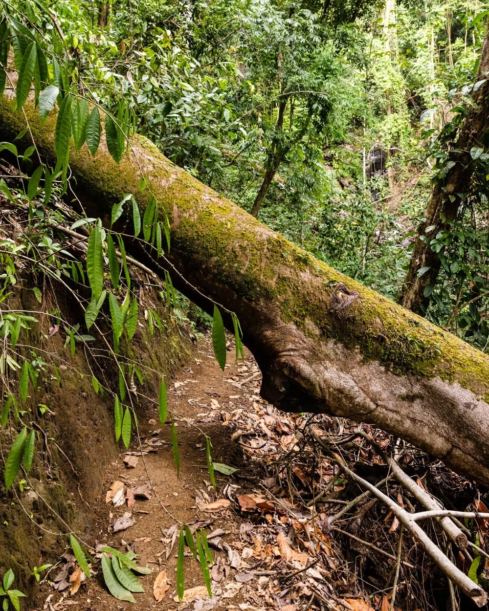
From here you continue descending, first on steps and then a dirt track. In the dry season the track was not muddy, but the loose soil still made it slippery in parts.
It’s the sort of track you probably want to go down quickly and confidently - something I struggle with when I think I might slip.


You can sort of mark your progress as you pass a series of letters along the trail, which are marked on your map.
However, on the way down it made me think the waterfall was much further away than it really was because the first few letters have quite big gaps, whereas the last few come thick and fast.

Descending through the jungle
You’ll pass your first landslide after 350m, but the track has been cleared nicely, so it’s not a treacherous crossing by any means.
We’d already seen three Scarlet macaws by this point, which added to the amazing rainforest scenery, and really made the track feel wild. It’s actually the most Scarlet macaws we’ve seen anywhere in Costa Rica - we saw 8 along this walk alone!

At the 550m mark you’ll see the signpost B (A was the toilet), but it doesn’t really mark anything in particular, the trail continues in much the same vein.
The dirt path can be pretty steep and it rarely has stairs, but the scenery is gorgeous. It’s true jungle vibes and the lack of other people on the trail gave it an extra special feel.


The dense forest also made the track very shady, which I was really grateful for because the temperature was up in the 30C’s and the humidity was exactly what you’d expect from a Costa Rican jungle environment!
After another 550m (1.1km) into the trail, you’ll see the C marker.

Continuing down to the creek
The descent continues and you’ll pass evidence of another landslide. We also saw two giant trees come down before our very eyes in another part of the forest, which definitely left us feeling this hike was more adventurous than most.
You’ll head deeper and deeper into the forest and come to a small creek crossing at just over 1.6km into the hike.
In dry season the rocks were fully exposed and it was easy to cross (it’s really just a few steps) I guess in rainy season it might be more significant.

The trail will get much easier as it all but flattens, and you can stop watching your feet (if you’re like me!) and really take in all the incredible jungle scenery.
At just over 1.7km into the trail you’ll reach a bench with a shelter if you want a break, and there’s a sign for the waterfall. This is where you’ll see the D marker.

Reaching the end of the descent
The next section of track is flat and easy, a welcome break from the steep descent. It’s just a 400m leisurely stroll before you see the E marker.
On the map this is marked as a river access point (where you can swim) but the reality is that it’s really overgrown. There are slightly better side trails to the river at markers F and G.

The F marker is just 50m from E, and this has a path down to the river. It starts off as steps but then gets a lot rougher. We had planned to hike to the bottom of the falls and then swim on the way back, but a sudden onslaught of thunder and wind meant we skipped the swimming as this is not an area we wanted to get caught in a storm!
It’s a shame because I’d normally never miss the chance to swim, but it wasn’t worth the risk. If you make it to either of the swimming holes, I’d love to know what they’re like!
The G marker is just a 150m easy walk from the F marker, and this is where you’ll reach a junction between the waterfall and the river (for the second swimming hole).

We headed left for the falls. We did take a really quick peek at the trail to the river on the way back and it started off easy and then got narrow and muddy, as well as being a bit steep.
Reaching the bottom of Bijagual Falls
From the trail junction you’ll start heading uphill on a wet stony path. It flattens after 100m and becomes a dirt track once again. There is a little more uphill to go, but it’s not steep.

There are roped handrails in place which I guess are more for the descent than ascent. You’ll find the H trail marker 250m from G (and 2.6km into the hike).

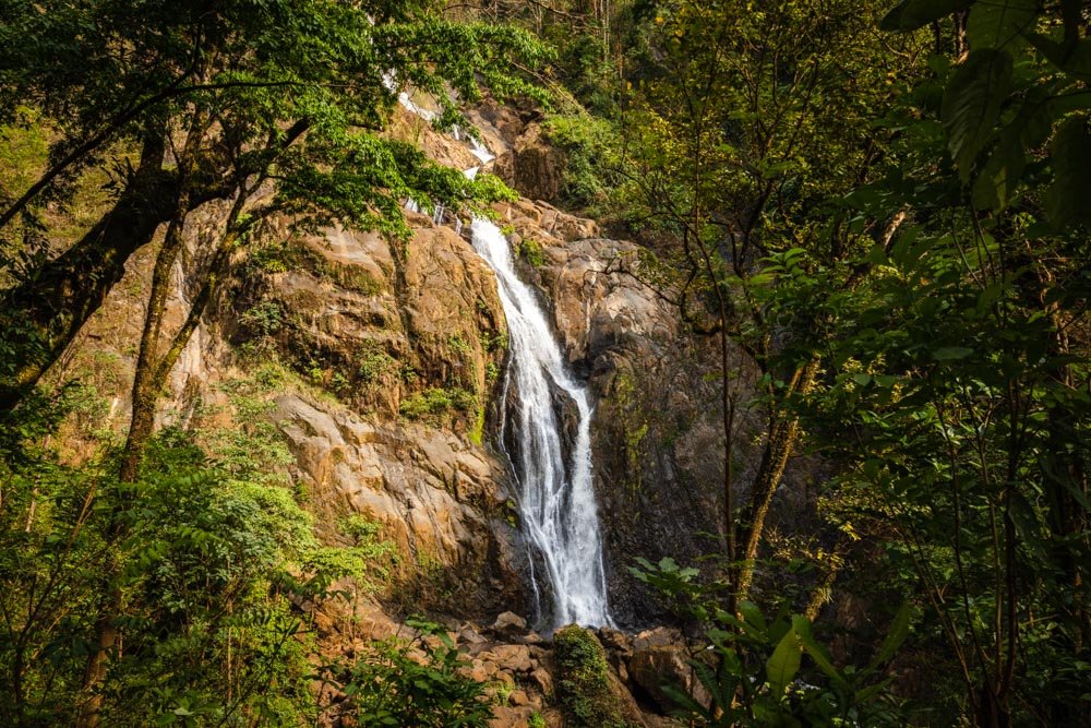
You then have a little water crossing to do as the track passes beside a small cascade. This is easy in the dry season and just involves rock hopping.

The track continues heading gently uphill and you’ll reach the small metal ladder 200m later.

It’s a short ladder and there’s a rope beside it if needed. I wouldn’t say it feels firmly fixed as such, but it’s not scary in any way, and it’s not exposed.
You’ll then cross a rustic wooden bridge which wobbled a touch, but felt sturdy enough.

You’re then just 50m away from a bench seat and the best view of the falls.
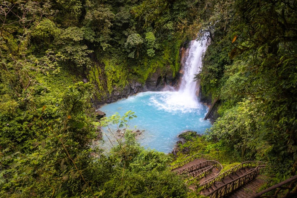
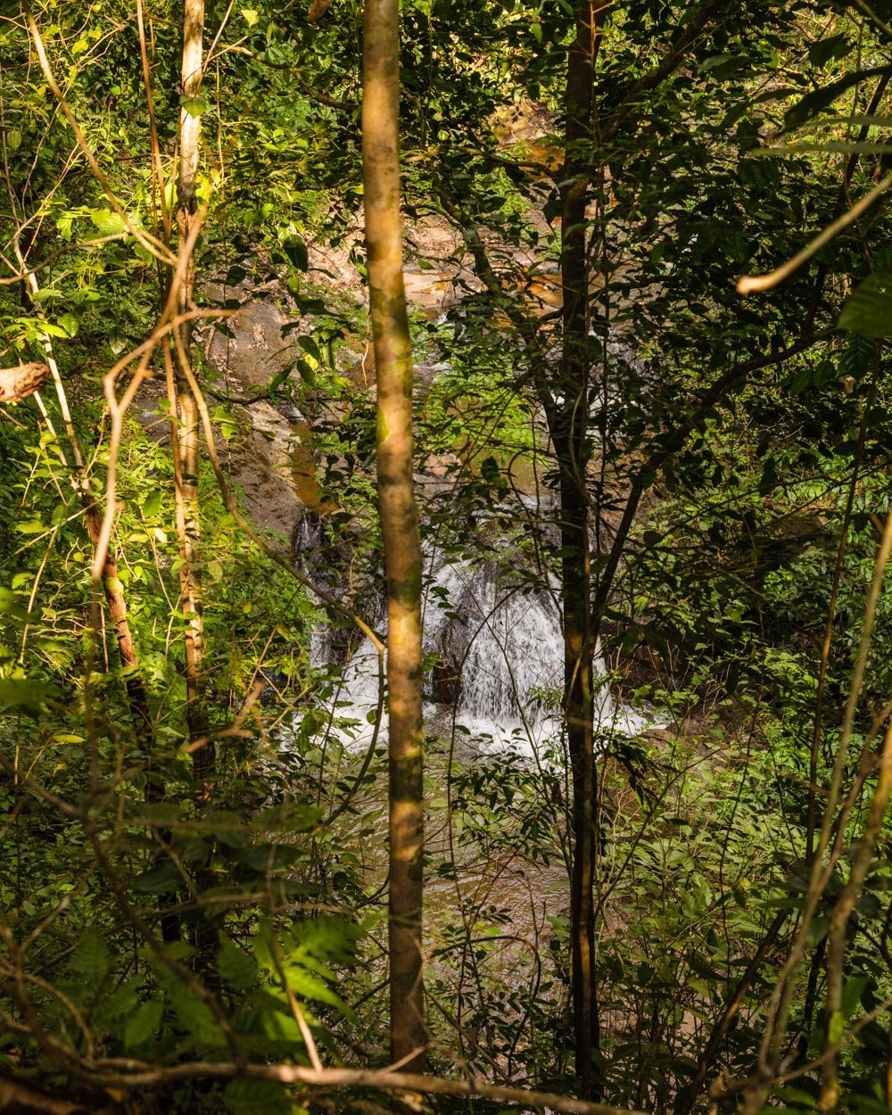
Bijagual Falls (Manantial de Agua Viva)
Although you can’t see all the way to the very top of the falls, the view is still great. The waterfall flows down a giant cliff and the setting is rugged and dramatic. Even in the height of the dry season there was a decent flow, although not as much as in many other waterfalls we visited in Costa Rica.

It’s a beautiful waterfall and the untamed nature of the track, as well as the lack of other people around, made it feel like a real hidden gem.
You can continue down past the viewpoint, which is rocky and has a rope in place. It’s not hard though and after 30m you’ll reach the final marker, I. There are then a few rustic stairs downhill before it gets rocky once again. There is one more small ladder and from there it’s boulder hopping to the very base of the falls.


We nearly got to the base before the thunder started getting more intense. What we can tell you though is that you can’t see the waterfall as well as from the viewpoint and there’s a lot of spray!
Climbing back up
Once you’re ready to leave the falls it’s time to start the climb. I’d say it’s pretty easy going until you reach marker D, which is just over a kilometre away. From there it quickly gets steeper and remains so right the way to the top. It doesn’t actually take that long, but it’s a pretty hot, sweaty affair!

I was watching for the trail markers but after C I somehow missed B, so thought it was a real slog as I couldn’t believe how long it was taking me to reach it. I was then pleasantly surprised to suddenly find myself at the top!
Overall, it was a great hike, but definitely steeper than I’d been expecting - although as you’re hiking to the bottom of a huge waterfall, I should probably have assumed it would be steep!
The one thing I would say though is that it feels quite remote. Although the person collecting the entry fee does write down your name and email, they do leave before closing time. For this reason I wouldn’t personally hike it alone in the late afternoon. If you did run into difficulties you might not see anyone to help you, and we had no phone signal (with Claro).

Bijagual Falls/Manantial de Agua Viva entry fee and opening hours
At time of writing the cost is USD $20 per person. This is quite steep for the trail in my opinion. However. it’s a small operation with just a hut at the side of the road, so you may be able to haggle a little!
The fee is the same for the middle falls entry point as well.
The sign said the waterfall is open from 7am until 4pm, however online it says 8am - 3pm. I imagine it’s the former because there’s no entry gate, so I doubt they want to risk people heading down for free!
Getting to Bijagual Falls/Manantial de Agua Viva
The entrance to the waterfall is located around 24km and a 35 minute drive from Jaco. The last 4.5km of the road is unpaved and uphill. It’s passable in a small car in the dry season (we did it in a small car), but it’s potholed and was a touch skiddy going uphill in our car after rain, so a SUV would be preferable.
The road used to be paved and in good condition, but fell into disrepair after a particularly bad rainy season. it may be fixed in time and then you’d have no trouble in any car.
Note that on Google maps the lower entrance for the waterfall is known as Manantial de Agua Viva, not Bijagual Falls.
This post may contain affiliate links, meaning at no additional cost to you, we will earn a small commission if you click through and decide to make a purchase. This helps towards the costs of running our website. Thanks for your support.